Design, amenity and shopfronts supplementary planning document
Policy Context
Why is good design important?
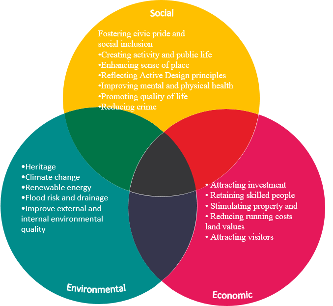
Good design is so much more than aesthetics. Good design can radically enhance social, economic and environmental indices, creating sustainable developments which have significant positive impacts on both the lives of individuals and their wider communities (figure 5).
The importance of good design is addressed both within local Policy and within the NPPF.
Policy DM.24 in the Wyre Forest Local Plan sets out that ‘All development will be expected to be of a high design quality. It will need to integrate effectively with its surroundings, in terms of form and function, reinforce local distinctiveness and conserve, and where appropriate, enhance cultural and heritage assets, landmarks and their settings.’
Furthermore, the NPPF (2023) states within paragraph 131 that ‘the creation of high quality, beautiful and sustainable buildings and places is fundamental to what the planning and development process should achieve.’
Fitting in with other guidance
The SPD aims to provide guidance and clarity around the key Design policies in the WFDC Local Plan and provide detailed guidance to be used by applicants, Planning Officers and Committee Members throughout the planning process.
How can applicants prove development is good design?
There are a range of tools available to guide the design of developments to ensure that the final product is of good quality. As set out in paragraph 133 of the Framework, these tools and processes are of most benefit when applied early in the evolution of schemes to prompt discussions and refine options. They can be used to involve relevant stakeholders, including built environment and non-built environment professionals, decision makers and the local community.
Available tools include (but are not limited to):
- National Design Guide
- National Model Design Code
- Local design guides and codes
- Design review
- Assessment frameworks
These tools can be used by developers to help evolve and assess the design aspects of proposals, and for the purposes of community engagement.
In this section
- Introduction
- An Introduction to Wyre Forest
- Design Objectives
- Residential Infill development
- Largescale Residential
- New Builds
- Employment developments
- Existing residential
- HMO Standards
- Listed buildings and Conservation
- Shopfronts
- Advertisements
- Public Realm - town centres
- Green Belt and Rural Areas
- Appendix
Policy context
National Policies:
National Planning Policy Framework
Guidance:
- Planning Practice Guidance
- National Design Guide (2021)
- National Model Design Code (2021)
Wyre Forest District’s Policies:
Adopted Local Plan (2016- 2036)
Relevant guidance:
- Worcestershire County Council Landscape Character Assessment Supplementary Guidance (2011)
- Wyre Forest Cycle Strategy (2002)
- Shopfront Design Guidance within Historic Environment SG (2004)
- Public Realm Design Guide for Stourport on Severn (2006)
- Churchfields Masterplan SPD (2011)
- Affordable Housing SPD (2014)
- Health SPD (TBC)
- Housing SPD (TBC)
- Biodiversity/ Infrastructure SPD
- Neighbourhood Character Appraisals
- Householder Validation User Guide (TBC)
- Design and Place SPD
Design and Access Statements
What is the role of Design and Access Statements in achieving well-designed places?
Design and Access Statements (DAS) set out the narrative for the design approach and design rational for the scheme. They demonstrate how the local character of an area has been considered and how design principles will be applied to achieve high quality design. They set out concisely how the proposal is a suitable response to the site and its setting, taking account of baseline information.
What should be included in a Design and Access Statement accompanying an application for planning permission?
A Design and Access Statement must:
- explain the design principles and concepts that have been applied to the proposed development; and
- demonstrate the steps taken to appraise the context of the proposed development, and how the design of the development takes that context into account.
A development’s context refers to the characteristics of the application site and its wider setting. These will be specific to the circumstances of an individual application and a Design and Access Statement should be tailored accordingly.
Design and Access Statements must also explain the applicant’s approach to access and how relevant Local Plan policies have been considered. They must detail any consultation undertaken in relation to access issues, and how the outcome of this consultation has informed the proposed development. Applicants must also explain how any specific issues which might affect access to the proposed development have been addressed.
What should be included in a Design and Access Statement accompanying an application for listed building consent?
Design and Access Statements accompanying applications for listed building consent must include an explanation of the design principles and concepts that have been applied to the proposed works, and how they have taken account of:
- the special architectural or historic importance of the building;
- the physical features of the building that justify its designation as a listed building; and
- the building’s setting.
Unless the proposed works only affect the interior of the building, Design and Access Statements accompanying applications for listed building consent must also explain how issues relating to access to the building have been dealt with. They must explain the applicant’s approach to access, including what alternative means of access have been considered, and how relevant Local Plan policies have been considered. Statements must also explain how the applicant’s approach to access takes account of matters (a)-(c) above.
Design and Access Statements accompanying applications for listed building consent must provide information on any consultation undertaken, and how the outcome of this consultation has informed the proposed works. Statements must also explain how any specific issues which might affect access to the building have been addressed.
Masterplans and Design Codes
What are masterplans?
Masterplans set the vision and implementation strategy for a development. They are distinct from local design guides by focusing on site specific proposals such as the scale and layout of development, mix of uses, transport and green infrastructure. Depending on the level of detail, the masterplan may provide an indicative layout of buildings, streets and public realm. More specific requirements for the site’s development may be set out in a design code and a series of parameter plans, which can accompany the overall masterplan. A range of other plans and technical reports may be needed alongside a masterplan, to provide supporting evidence and set out related proposals, such as a local character study, landscape assessment, transport assessment and proposals for securing biodiversity net gain. An implementation strategy could also be included, especially where development is expected to be brought forward in several phases.
How can masterplans be used most effectively?
Masterplans help the Council to assess at an early stage in the development process the relationship between key design issues and how the provision and integration of key design elements can contribute to successful places. Masterplans can benefit from a collaborative approach between the local planning authority, site promoters and local communities so that aspirations and constraints are understood early on. Care should be taken to ensure that masterplans are viable and well understood by all involved and that graphic representations of what the development will look like do not mislead the public by showing inaccurate details or significant elements not yet decided upon
What should be presented on a Masterplan?
Existing:
- Site Context i.e., surrounding permeability, services, landmarks, existing access connections
- Existing surrounding development
Proposed:
- Perimeter blocks including mass, height, orientation block structure etc
- Proposed open space and landscaping
- Proposed access
- Proposed services
- Proposed location of the site and the boundaries of the development in relation to the surrounding areas of land
- Proposed surrounding development
The masterplan should describe and map an overall development concept, including present and future land use, urban design and landscaping, built form, infrastructure, circulation and service provision. It is based upon an understanding of place, and it is intended to provide a structured approach to creating a clear and consistent framework for development. For more complex applications, the submission of material that shows design development and testing, including concepts or arrangements that have been pursued and subsequently discounted are particularly encouraged as this material will help to support decision making.
What are Design codes
Design codes are a set of illustrated design requirements that provide specific, detailed parameters for the physical development of a site or area. The graphic and written components of the code should build upon a vision, such as a masterplan or other design and development framework for a site or area. Their content should also be informed by the 10 characteristics of good places set out in the National Design Guide, and the National Model Design Code. WFDC require design codes to be used in considering custom and self-build and outline planning applications.
What to include in a Design and Access Statement
- Introductions and vision
- Vision and background of the proposed development
- Wider context of the site
- Relevant planning and policy context
- Site Assessment
- Historic context
- Settlement character
- Landscape and Ecology
- Movement
- Summary of Analysis
- Design Evolution
- Strategic allocation concept
- Design concept plan
- Draft framework plan for stakeholder engagement and feedback
- Framework masterplan
- Design Principles
- Landscape and Ecology
- Access and movement
- Uses
- Building heights and density
- Phasing
- Character areas
- Illustrative masterplan
- Appendix
- Building for a Healthy Life assessment
- Building with Nature assessment
Figure 8. Silverwoods. Credit: Pegasus
Figure 9: A breakdown of each stage when preparing a Design Code
Stage 1: Analysis
- Scoping: agreeing on the geographical area to be covered by the code.
- Baseline: the analysis that will underpin the code and inform its contents.
Stage 2: Vision
- Design Vision: dividing the area covered by the code into a set of typical ‘area types’ and deciding on a vision for each of these area types.
- Coding Plan: preparing a plan that maps out each of the area types.
Stage 3: Code
- Guidance for area types: developing guidance for each area type.
- General guidance: agreeing on a set of policies that will apply equally across all area types.
Accessible text alternatives to diagrams
Figure two - the benefits of good design
Three part Venn diagram
1. Social
Fostering civic pride and social inclusion
- Creating activity and public life
- Enhancing sense of place
- Reflecting Active Design principles
- Improving mental and physical health
- Promoting quality of life
- Reducing crime
2. Environmental
- Heritage
- Climate change
- Renewable energy
- Flood risk and drainage
- Improve external and internal environmental quality
3. Economic
- Attracting investment
- Retaining skilled people
- Stimulating property and
- Reducing running costs land values
- Attracting visitors
Let us know your comments
We welcome your comments and feedback. Consultations runs until 5pm Wednesday 8 May 2024.