A Sustainable District 2046
What is the Local Plan?
The Local Plan is a document which sets out the long-term vision and strategic context for managing and accommodating growth within the District until 2046 in order to contribute to the achievement of sustainable development. It allocates land for new development and protects important areas such as environmental assets, historic buildings and archaeology. It is a legal requirement for every council to have an up-to-date Local Plan to manage development in a planned and coordinated way and to help ensure that development needs are met in a planned rather than reactive way, aiding us with maintaining a 5-year housing land supply.
Whilst the local plan itself doesn’t provide infrastructure or directly deliver services such as utilities, roads, health care or public transport, it provides the planning framework for relevant infrastructure providers and partners who deliver such services in coordination with development.
Wyre Forest’s current Local Plan was adopted in April 2022 and no longer fully reflects national planning policy or local circumstances. The new Local Plan will set out a vision for Wyre Forest District up to 2046. It will contain policies to guide planning decisions and new development. The government requires all councils to maintain an up to date Local Plan to ensure that development is planned in a way which meets the future needs of the growing community.
What is the Spatial Issues and Local Priorities Paper?
The ‘Spatial Issues and Local Priorities’ consultation is the initial stage of the Local Plan Review process. It seeks to engage with residents, businesses and stakeholders in shaping the emerging plan.
At this stage, we are asking for your views on:
- Whether the key issues affecting the District have been correctly identified.
- Which of the options identified are the most appropriate for addressing those issues.
The responses you provide will help to inform the new Local Plan for Wyre Forest District Council. Following the close of the Spatial Issues and Local Priorities consultation, all responses will be summarised, and the Council will respond to them.
How to Comment
Consultation on the Spatial Issues and Local Priorities Paper will take place between 17th August and 28th September. We encourage responses to be made online, however comments can also be submitted in any of the following ways
- On-line by following the link from our website (Spatial Issues and Local Priorities Consultation Survey)
- By e-mail: Planning.policy@wyreforestdc.gov.uk
- By post: Planning Policy Team, Wyre Forest DC, Wyre Forest House, Finepoint Way, Kidderminster, Worcestershire, DY11 7WF
The plan making process
The Local Plan preparation process.
| Key steps in new Local Plan system | Description |
|---|---|
| Publish local plan timetable | The timetable must be kept up-to-date and set out the anticipated and actual dates for key plan-making stages. |
| Publish notice of intention to commence local plan preparation | Publication of notice which commences a minimum 4‑month notice period so that stakeholders are aware plan-making is beginning. |
| Scoping consultation | Inviting feedback from stakeholders on how to engage with them and what the plan should contain. |
| Gateway 1: self-assessment of readiness | Publication of a document setting out details of how ready for plan-making the authority is, marking formal commencement of plan-making for the purposes of the 30‑month timeframe. |
| Consultation: proposed local plan content and evidence | Minimum 6‑week consultation on the proposed local plan content and evidence, including a draft version, not including the outcome of the call for sites. |
| Gateway 2 | Seeking observations and advice from the Planning Inspectorate (PINS) to support early resolution of potential soundness issues and progress towards the ‘prescribed requirements’. |
| Consultation: proposed local plan | Minimum 8‑week consultation on the proposed local plan and its supporting documents. |
| Gateway 3 | Testing whether the proposed local plan has met the ‘prescribed requirements’ and can proceed to examination. |
| Examination | Examination of the local plan against the tests of soundness, as set out in national policy. |
| Adoption | Publication of the local plan and adoption statement. |
Wyre Forest Vision
It is essential that the Local Plan is marked by a clear vision of where we want Wyre Forest District to be as a place to live, work, learn and visit by 2046. Once agreed, the vision will represent the overall goal by which we aim to make the District, and it will form the underpinning basis of which the plan is formed upon.
The proposed draft vision for the District is as follows:
“By 2046, Wyre Forest will be a sustainable, well-connected and thriving district where the distinct, separate identities of Kidderminster, Stourport-On-Severn and Bewdley are maintained as the main focus for growth, supported by outlying villages which have in turn grown to meet needs locally and across the District as a whole. Growth will be focused in the most sustainable locations, providing a high-quality housing market that caters for all, with job creation balanced with housing delivery to encourage younger people to remain within the District, whilst respecting the character and heritage of each place. The District will support a vibrant and resilient economy with thriving town centres, a strong rural economy, sustainable tourism and access to education, skills and training opportunities.
The District’s identity will continue to be shaped by its valued natural environment, including the River Severn, River Stour, the Staffordshire and Worcestershire Canal and the wider green infrastructure network, which will be protected and enhanced to support biodiversity, landscape character, recreation, sustainable travel and climate resilience. Development will incorporate high standards of environmental sustainability, with businesses and residents relying increasingly on renewable energy sources and water management forming an integral part of planning and design.
A well-connected transport network will support easier and safer movement across the District, with improved Active Travel routes for walking, wheeling and public transport helping to reduce reliance on the private car and in turn improve air quality. New development will be supported by the timely delivery of infrastructure such as community facilities and services needed to meet the needs of existing and future residents.
Overall, Wyre Forest will continue to be a place where its natural environment, waterways and built heritage work together to support healthy, sustainably communities, thriving town centres, flourishing evening economies and a successful environment for present and future generations.”
Key issues and challenges
Wyre Forest is changing and will continue to change in the future. A number of national changes have occurred since the last Local Plan which will influence how the district develops over the plan period.
The following sections will set out the key local issues faced by Wyre Forest District and looks at what options are available to overcome them moving forward. We need your input to help us understand what you feel are the key priorities for the district and what you feel is the best approach at tackling these issues.
The Government’s standard method for calculating housing needs indicates that the District is now required to plan for a minimum of 584 dwellings per year, compared to the prior requirement of 276 dwellings per year. This represents a significant increase in housing need and presents a key challenge ensuring that sufficient homes, employment land and infrastructure are provided.
Wyre Forest also faces a range of other social, economic and environmental challenges, including:
The population consists of a high proportion of older residents, increasing the demand for care facilities and specialist accommodation. Housing affordability is also a key issue and future housing delivery will need to cater for all groups, including enabling older residents to downsize if desired.
There are also noticeable health inequalities between those living in the most affluent wards and those living in the most deprived wards in the district. Such inequalities present challenges for future health services provision and planning for healthy communities.
Since the 1970s there has been continued decline in traditional manufacturing, alongside a continuing need to provide a wider range of employment opportunities. A significant proportion of residents commute outside of the District for work, indicating a strong need to strengthen the local employment base and improve access to higher value jobs and training to reduce the wage gap between WFDC and neighbouring local authorities.
Over half of the District also falls within the West Midlands Green Belt which creates an increasing pressure to protect our Green Belt as demand for housing increases. It is therefore important to balance the need for growth with the protection of the Districts environmental assets, landscape character and heritage.
Traffic levels and congestion are increasing and becoming a prevalent issue, with the District currently containing two Air Quality Management Areas (AQMAs) already in place at the Horsefair, Kidderminster and Welch Gate, Bewdley.
We want to understand what issues are important to you and what type of place you would like the District to become moving forward.
The new Local Plan will set out a vision for Wyre Forest until 2046. We will need to consider issues regarding climate change, infrastructure, and growth within the district.
The Climate Emergency
Climate change is one of the most significant challenges facing communities globally. In response to this, the council declared a climate emergency in 2019 and has since produced a Climate Action and Carbon Reduction Plan 2024-2027 [Our climate action and carbon reduction plan | Wyre Forest District Council]
Greenhouse gases have increased in the atmosphere by 50% in under 300 years. The primary cause of this rise is the direct combustion of fossil fuels (for the likes of transport and manufacturing), land use change (especially deforestation), industrialised animal agriculture and overconsumption. As climate change worsens, dangerous weather events are occurring more frequently and severely upon a global level, leaving devastating consequences upon communities and ecosystems.
Climate focused initiatives that have already been taken by WFDC include providing renewable energy grants to landlords, promoting the fitting of solar panels on new developments, ensuring all new developments include EV charging points, additional recycling bins across the district and the adoption of the banning of single use plastics across Council occupied properties.2
As a result, the Council aims to achieve net zero by 2050 by reducing emissions as much as possible in line with national targets.
With climate change accelerating, flood risk becomes a greater concern. Areas of the District are already subject to regular flooding due to existing drainage systems and watercourses becoming overwhelmed during or following heavy rainfall. New developments are required to provide flood mitigation methods and provide appropriate buffering between watercourses and development to combat this issue, also considering surface water impacts to and the use of Sustainable Drainage Systems (SuDS) to reduce future flood risks.
The council now needs to determine how we should best respond to the climate emergency, including reducing carbon emissions and adapting to climate risks. We have a few options on how we could tackle these:
- Focusing on low carbon development, reducing emissions through use of renewable energy, EV infrastructure and sustainable construction methods.
- Prioritising tree planting, biodiversity and green infrastructure with a more nature-based approach.
- A sustainable transport approach, prioritising brownfield regeneration and encouraging walking and cycling to reduce reliance on cars and reducing emissions.
We need your views on these approaches, with the consultation questionnaire linked above giving you the opportunity to share your opinions on whether we should follow, one, more or all of the previous options.
Housing for the Next Generation
Wyre Forest is home to an ageing population, with a very high proportion of residents aged 65+, highlighting the need for more downsizing opportunities, care facilities and specialist accommodation. Whilst the population of Wyre Forest has increased to approximately 101,600 according to the 2021 Census [Wyre Forest population change, Census 2021 – ONS], in comparison to the 2011 population of 98,000, the number of households has increased at a far greater rate since the number of residents per unit of accommodation is falling. The population aged 65 years and over is projected to represent 27% of the population in Wyre Forest by 2032, up from 24% in 2022. [Subnational population projections for England - Office for National Statistics]
There is a national housing shortage across the UK with the government requiring that 584 new homes need to be built per annum within Wyre Forest District. If the council fails to meet housing targets, the government may step in to determine planning applications within Wyre Forest. Therefore, we need your opinions on what types of homes should be built, and where.
The Local Plan needs to ensure that new housing meets the needs of the local community, therefore we need your opinions on what types of homes should be prioritised.
We have a few options as to how we could prioritise development:
- Mixed approach, providing a range of house sizes to accommodate for all.
- Affordability focused approach, prioritising social rented, affordable housing, and shared ownership to allow more people to get on the property ladder.
- Specialist accommodation approach, prioritising homes for older people such as downsizing, care facilities and a self/custom build approach.
Where Should New Growth Go?
The best form of sustainable development is where there are the largest range of local facilities, minimising the need for travelling long distances. The provision of good public transport, including access to rail services, together with opportunities for walking and cycling are also key components of sustainable development. As shown in Figure 1, the larger a settlement, the greater the connectivity. This suggests Kidderminster, Stourport and Bewdley would be the most sustainable or connected locations, suggesting growth be proportionate to each town.
We need your opinions on where to focus new development, whether it be one, more, or all of the following options:
- Focusing new development to extend from existing settlements and allow for a gradual expansion, making use of existing services and public transport, including rail where appropriate.
- Prioritising brownfield (previously developed) land within settlements for development.
- A new settlement approach, delivering growth through the development of a new community.
- Focusing new development on the smaller, more rural areas of the district, bringing new homes and facilities to these areas.
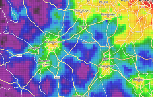
Figure 1: Heat map showing distribution of connectivity within Wyre Forest and surrounding areas [Connectivity Tool]
Jobs for local people
Since the 1970s, there has been a gradual reduction in traditional manufacturing industries, moving away from the traditional carpet manufacturing base which the area was internationally renowned for. The district has a relatively poorly qualified workforce, which on average earn less than others across the region and country. It is likely that many people are commuting to Worcester or Birmingham for higher paid jobs, with about 40% of residents commuting to outside the district for work.
As more homes are built, a need is created for more work opportunities. The district has high levels of people commuting to work outside the district, and a relative shortage of high paid jobs. New businesses also struggle to find accommodation, and the Government supports more research and development.
To combat this, we have a range of options, and we need your opinion to help decide whether one, more or all of the following approaches are best moving forward.
With new businesses struggling to find accommodation, one option would be a growth focused approach, allocating additional land for employment development to support job creation within the district.
Another option would be a small business focused approach, ensuring new development always includes smaller units suitable for start ups or small, local businesses which may otherwise not be able to develop.
As the district has a relative shortage of high paid jobs, and high levels of people commuting to work outside of the district, there could be a training focused approach, ensuring new developments for employment have training opportunities for local people to upskill.
Alternatively, we could adopt a combined approach, ensuring new developments incorporate all the above, rather than prioritising one option above another.
Infrastructure
Infrastructure such as utilities, flood defences and community facilities are essential for supporting residents and businesses.
As Wyre Forest grows as a district, it is vital that infrastructure grows in line with growth to support residents and businesses. The council will work in partnership with the organisations that provide these. We know there are concerns about infrastructure and want your views on where the focus should be.
Key strategic issues relating to infrastructure include the need to regenerate the town centres, particularly Kidderminster, mitigating traffic congestion particularly around the two Air Quality Management Areas (AQMAs), encouraging more visitors to the area whilst also supporting housing and employment development. In terms of community facilities, with obesity levels being higher in the district compared to the UK as a whole, there is increased stress upon GP and medical facilities within the district and a need for focus upon active travel. There is also a need for services to be more accessible in the district’s rural areas, with improvements to public transport and strategic transport infrastructure.
It is an understandable concern that with increasing pressures of new housing and development within the district, the necessary infrastructure needs to be provided alongside this to support sustainable communities and lessen existing concerns.
Therefore, we need your opinion on what types of infrastructure should be prioritised to support the inevitable growth of the district. The options include:
- A transport led approach, focusing on investment in public transport and active travel infrastructure to reduce the reliance on cars and reduce congestion / air quality issues.
- A social infrastructure approach, focusing on the delivery of essential services such as healthcare facilities and schools, which are currently under pressure with a growing community.
- A community focused approach, supporting the development of green infrastructure, parks and sports infrastructure to improve health and life quality.
- A balanced approach with a combination of all of the above, not prioritising one above another.
Improving the three town centres
Wyre Forest District is made up of the three main towns, those being Kidderminster, Stourport-on-Severn, and Bewdley. Each town has its own character and community identity. Kidderminster (hosting a population of 57,400 in 2021) is the largest and is the main centre for retail, industry and housing. Whilst Kidderminster used to be a world leading centre for carpet production, since its traditional manufacturing decline in the late 1970’s, its economy has since diversified with the town centre recently benefitting from £40m of investment to strengthen the visitor, cultural and nighttime economy.
Stourport-on-Severn (hosting a population 20,653 in 2021), developed as an important industrial Georgian Canal Town, having made a popular day trip destination for residents from Birmingham and the Black Country.
Bewdley has a population of approximately 9,300 and is an attractive historic market town and popular visitor destination.
Many town centres are in decline with competition from internet sales, and the overall traditional role of our towns are changing from being mainly places to shop, to places where we spend time socialising. The Council seeks to maintain these areas as vibrant places and bring energy back to our three town centres in a way that meets the needs of residents.
There are a number of options available which can shape improvements within the three town centres, but we need your opinions upon what is preferred.
Whilst town centres were primarily places to shop, we could aim to introduce more leisure facilities to encourage residents into town centres whilst still offering a range of retail choices. This would comprise of encouraging a mix of shops, restaurants, cafes, pubs and leisure with the aim of increasing activity and footfall in years to come.
Alternatively, we could take a more living and working approach, with an increasing number of people working from home, promoting the development of homes above shops and redevelopment of town centre buildings to create flexible workspaces could support town centres throughout the day.
With infrastructure concerns surrounding parking, congestion and air quality, we could focus upon improving public transport, considering introducing park and ride schemes alongside improving walking and cycling measures.
Congestion and Air Quality
The transport network includes railway lines, roads, cycleways and footpaths. Wyre Forest is well connected to the strategic road and rail network, but the district has become very congested at times particularly around Kidderminster town centre, the A451 Stourport Road and the B4190 approach in Bewdley. This makes journeys slower and increases air pollution.
There are two locations in the district currently being monitored because of air quality concerns which include the Horsefair, Kidderminster extending to include part of the Kidderminster Ring Road, and Welch Gate, Bewdley. The Air Quality Management Areas (AQMAs) have been declared due to exceedances of the annual mean objective (40 µg/m3) for nitrogen dioxide, attributable to road traffic. [WFDC AQMA]
Wyre Forest Air Quality Action Plan [Wyre Forest Air Quality Action Plan | Wyre Forest District Council] shares concerns received from the public surrounding the expected increase in congestion on district roads with proposed housing growth, therefore we need your opinions on how best we can manage air quality and congestion within the district.
In other areas regionally where congestion is an issue, a variety of schemes have been tried to address these concerns and improve road safety for all.
School safe-haven zones are temporary, car-free zones surrounding schools operating during drop-off and pick-up times to increase safety, reduce congestion and encourage walking or cycling, restricting most motor vehicles. Such schemes have been adopted by other regions including Derby, Bristol, Herefordshire, Dorset and Hackney councils.
Schemes utilised by other areas regionally to combat congestion and air quality include clean air zones (CAZs), congestion charging zones, bus prioritisation schemes through the implementation of bus lanes, 20mph speed limits, pedestrianisation of towns, and development of low traffic neighbourhoods using barriers or cameras to reduce through-traffic. These are all options which could be utilised to combat the issues surrounding congestion and air quality within our district.
Biodiversity
Wyre Forest District has extensive areas of woodland, grassland and marshland, many of which are protected as Sites of Special Scientific Interest (SSSI) or Local Wildlife Sites (LWS). Many of the larger nature sites are immediately adjacent to residential estates, bringing nature within easy walking distance of a large proportion of the population.
However, biodiversity is under increasing pressure from climate change, habitat fragmentation and development. Protecting and enhancing the natural environment is therefore a key issue for the new Local Plan.
Since the adoption of the previous local plan, which aimed to provide a net gain for biodiversity, the implementation of the Biodiversity Net Gain (BNG) requirement came into force as a legal requirement in 2024 [Scoping document for Biodiversity Net Gain SPD | Wyre Forest District Council]. This requirement means that all new planning developments must deliver a minimum of 10% net gain in habitat value, ensuring the natural environment is left in a better state than before.
The Local Nature Recovery Strategy [JN2526.188 LNRS Public Consultation Document] sets out a clear vision and practical actions to halt and reverse the decline of nature in Worcestershire, but we need your opinions on how best we should focus efforts to improve biodiversity within the district.
We would like your views on
- How open spaces should be improved and connected
- How trees should be incorporated into new development schemes
- What measures should be introduced to better support wildlife within the local community
Healthier and safer communities
Ensuring our district hosts healthy and safe environments is key for residents to feel safe. As previous issues discussed, there is already pressure upon GPs and other medical facilities, which highlights a need for more accessible exercise and leisure facilities whilst ensuring residents feel safe to do so.
Whilst crime levels are considered low in comparison to national averages, there are crime hotspots within the district, primarily within Kidderminster, with residents expressing concern in the consultation for the last local plan of areas that host underpasses or alleys.
Promoting social interaction through opportunities for people who may not otherwise be able to socialise such as through access to development aimed at ageing populations, or community centres which can be accessed via improved active travel networks, would prove beneficial for keeping the community healthy and safe.
The Local Plan can influence health outcomes through the development of infrastructure which supports healthy and safe communities. There are a variety of options available to focus infrastructure to support this aim. These could include one, more or all of the following:
- Health focused through prioritisation of parks, open spaces and leisure facilities which would in turn support more active lifestyles.
- Community focused through prioritisation of access to community spaces and shops.
- Design focused through prioritisation of creating safe, walkable neighbourhoods with safety measures such as the introduction of 20mph zones in residential areas.
We need your view on these potential approaches, with the questionnaire exploring these priorities in more detail.