DRAFT Green infrastructure supplementary planning document
Draft for consultation
Consultation is now closed
Contents
Executive Summary
Introduction
What is Green Infrastructure
Legislative and Policy Context
Green Infrastructure Network Assets and Function
Green Infrastructure and Biodiversity Net Gain
Green Infrastructure Design Process
National Guidance
Local Guidance
Long Term Management of Green Infrastructure
Case Studies
Appendix One: Example s106 clauses regarding GI management
Wyre Forest Local Development Plan and Supporting Documents
Consultation opens 11th June 2025 to comment on the draft SPD please email planning.policy@wyreforestdc.gov.uk
The graph below shows the documents that make up the Local Development Plan. SPDs may be prepared by a Local Planning Authority to build upon and provide more detailed advice or guidance on adopted Local Plan policies and they must therefore be consistent with those policies. They do not form part of the development plan and cannot introduce new policies nor add unnecessarily to the financial burdens of development, but SPDs (once adopted) are material considerations to be taken into account in determining planning applications.

Executive Summary
Supplementary Planning Documents may be prepared by a Local Planning Authority to build upon and provide more detailed advice or guidance on adopted Local Plan policies and they must therefore be consistent with those policies.
The Wyre Forest District’s Green Infrastructure Supplementary Planning Document (SPD) provides more detailed advice on the Green Infrastructure related policies contained in the Wyre Forest Local Plan. This includes policies:
- 28 Green Infrastructure
- 23 Protecting and Enhancing Biodiversity
- 7 Open Space
- 8 Provision for Open Space, Sports Pitches and Outdoor Community Uses in Housing Development
- 24 Quality Design and Local Distinctiveness
This document also signposts to national and local guidance that provides further information and tools for an applicant when designing, developing and managing a development which contains green infrastructure.
The aim of this document is to ensure that when Green Infrastructure is part of new development, that it is well designed, environmentally sustainable and healthy environments for people to live and work within. It is aimed at assisting local authority planning officers, applicants, developers, relevant organisations, and the wider community.
Introduction
The inclusion of Green Infrastructure in new development is an important part of ensuring well designed, environmentally sustainable and healthy environments are created for people to live and work within.
The Wyre Forest District’s Green Infrastructure Supplementary Planning Document (SPD) provides more detailed advice on the Green Infrastructure related policies contained in the Wyre Forest Local Plan. It has been prepared in partnership with colleagues in the Planning team.
The SPD focuses on green infrastructure and how it should be positively addressed through the development management planning process in the district. It is aimed at local authority planning officers, applicants, developers, relevant organisations, and the wider community.
What is Green Infrastructure?
The National Planning Policy Framework defines Green Infrastructure as:
"A network of multi-functional green and blue spaces and other natural features, urban and rural, which is capable of delivering a wide range of environmental, economic, health and wellbeing benefits for nature, climate, local and wider communities and prosperity."
It includes:
|
Natural Assets |
Enhanced Assets |
Engineered Assets |
|---|---|---|
|
Wetlands |
Rain Gardens |
Permeable pavements |
|
Forests |
Green roofs and walls |
Rain barrels |
|
Parks |
Bioswales |
Cisterns |
|
Meadows |
Urban trees |
Perforated Pipes |
|
Lawns and Gardens |
Naturalised stormwater ponds |
Infiltration trenches |
|
Soil |
|
|
Well-designed multi-functional Green Infrastructure should:
- Support people’s mental and physical health
- Encourage active travel
- Help create high quality environments that encourage investment and thriving and prosperous communities
- Helps reduce flood risk, reduce pressures on the water environment and infrastructure and improve water quality.
- Make places more climate resilient and adaptive to climate change
Legislative and Policy Context

National Context
Government’s 25 year Environment Plan: the importance of green infrastructure particularly in urban areas, is emphasised in the Plan. It preceded the GI framework and standards, now published.
Environment Act 2021: sets targets for nature recovery and improvements to air quality, biodiversity, water, waste, and the reversal of the decline in species. The Act introduced mandatory Biodiversity Net Gain, Local Nature Recovery Strategies, Species Conservation and Protected Sites strategies. Green Infrastructure can be an important part of all of these.
National Planning Policy Framework: requires local planning authorities to set out an overall strategy and make sufficient provision for green infrastructure. It requires new development to provide or enhance green infrastructure as part of any development.
Natural Environment Planning Practice Guidance: states that Green Infrastructure opportunities and requirements need to be considered at the earliest stages of development proposals taking into account existing natural assets and most suitable locations and types of new provisions.
National Design Guide: sets out how well-designed places can include green infrastructure and gives good practice examples.
Natural England Green Infrastructure Framework and Standards: provides the national principles and standards around green infrastructure. The website also provides a green infrastructure mapping tool, a planning and design guide, process and journey tools and an Environmental Benefits from Nature Tool.
Local Policy Context
Worcestershire Green Infrastructure Strategy 2023- 2028 set out the county-scale principles and is aimed at establishing a coherent approach to green infrastructure across the county. It is referred to in the Local Plan, specifically in Policy SP.28 Green Infrastructure.
The Worcestershire Draft Local Nature Recovery Strategy: Worcestershire County Council are in the process of writing the Worcestershire Local Nature Recovery Strategy. Although the strategy post-dates the adoption of the Local Plan, the draft Local Nature Recovery Strategy has been reviewed and used to inform the guidance and advice in this Green Infrastructure SPD.
Wyre Forest District Council’s Local Plan (2016-2036): Policy SP.28 Green Infrastructure places an emphasis on the delivery of a comprehensive network of green spaces and corridors across the district. It sets out:
- the expectations of green infrastructure for greenfield and brownfield development sites
- provides information on how planners will deal with applications that have a detrimental impact, and;
- states how green infrastructure will be protected and managed in the long term (as per Policy DM.7 – Open Space).
Other policies of relevance include SP.23 Protecting and Enhancing Biodiversity, DM.7 Open Space, DM.8 Provision for Open Space, Sports Pitches and Outdoor Community Uses in Housing Development and DM.24 Quality Design and Local Distinctiveness.
Policy SP.23 Protecting and Enhancing Biodiversity states that WFDC expects proposed developments to deliver measurable net gains in biodiversity through the promotion and recreation of priority habitats, ecological networks and the protection and recovery of legally protected and priority species populations.
DM.7 Open Space provides detail on how new open space will be designated, protected and managed in the long term.
DM.8 Provision for Open Space, Sports Pitches and Outdoor Community Uses in Housing Development gives details on expectations for the provision of public open space, play areas and sports pitches in major housing developments.
DM.24 Quality Design and Local Distinctiveness includes requirements around landscaping, public realm and settlement character.
The purpose of this Green Infrastructure Supplementary Planning Document (SPD) is to add further detail to these policies, giving greater clarity to developers and communities about the expectations for green infrastructure in Wyre Forest.
This SPD cannot and does not introduce any new policy requirements; rather it provides additional guidance to help applicants understand how it is possible for proposed developments to satisfy existing plan policy.
Green Infrastructure Network Assets and Function
The district has a distinctive environment comprising diverse landscape character areas, including urban areas. There are many green corridors within the district which are currently fragmented but have the potential to provide a comprehensive network of green infrastructure (GI). The district’s watercourses, in particular, offer the opportunity to link the urban areas with the countryside beyond. The District also contains some of Worcestershire’s most important and distinctive acid/lowland heath communities and the continued protection and enhancement of these important areas needs to be considered in any future development.
Worcestershire’s draft Local Nature Recovery Strategy, the adopted Green Infrastructure Strategy (2023-2028) and their supporting evidence base seeks to enhance opportunities to link biodiversity with drainage, historic landscape character and improved accessibility. Figure 1 is the map taken from the Local Nature Recovery Strategy that shows there are large areas in Wyre Forest that need to be either protected and enhanced, protected and invested in or restored and maintained.
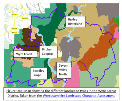
| Name | Objective |
|---|---|
| Wyre Forest | Protect and enhance |
| Severn Valley North | Protect and enhance |
| Hagley Hinterland | Protect and restore |
| Bewdley Fringe | Protect and restore |
| Birchen Coppice | Protect and restore |
Key
| Wyre Forest District boundary | |
| Sandstone Estate lands | |
| Wooded Forest | |
| Principal Wooded Hills | |
| Timbered Plateau Farmlands | |
| Wooded Estate lands | |
| Urban | |
| Estate Farmlands |
In addition, the draft Local Nature Recovery Strategy local habit map provides details on areas of particular importance for biodiversity, irreplaceable habitats and ancient woodlands. Figures 2 to 4 are taken from the habitat map showing these areas/habitats in the Wyre Forest District.
Figure 2: Areas of particular importance for Biodiversity in Wyre Forest

Figure 3: Wildlife and Geological Sites across Wyre Forest

Figure 4: Irreplaceable Habitats and Ancient Woodland sites in Wyre Forest

Green Infrastructure and Biodiversity Net Gain
Most developments must now demonstrate a mandatory 10% biodiversity net gain when applying for planning permission. There are, however, exemptions. These are:
- Development below a de minimis threshold. This exemption applies to development that does not impact a priority habitat and impacts less than 25 square metres on non-priority onsite habitat (such as modified grassland) or 5m for non-priority linear habitats (such as hedgerows). If any priority habitat within the red line boundary of the development is impacted, the exemption will not apply and all habitats will be subject to BNG.
- Householder development. This exemption applies to the development of an existing house (including development within the existing curtilage of a house). It does not cover applications for a change of use of a house or to change the number of dwellings in a building.
- Biodiversity gain sites. This applies to developments which solely enhance biodiversity to achieve a BNG planning condition or another development through off site enhancement of habitat; or a development undertaken to fulfil a BNG planning condition and for the purpose of permitting public access to use the site for educational or recreational purposes without paying a fee.
- Small scale self-build and custom housebuilding. This exemption applies only to development that consists of no more than 9 dwellings, is carried out on a site which has an area no larger than 0.5 ha and consists exclusively of dwellings which are self-build or custom housebuilding as defined in section 1(A1) of the Self-build and Custom Housebuilding Act 2015.
- High Speed Railway Transport Network.
- BNG will also not apply to retrospective applications
- Planning In Principle applications, although it will be required at technical details stage.
However, it should be noted that whilst these exemptions apply regarding the mandatory 10% Biodiversity Net Gain, the Council’s planning policies, notably Policy SP.23 Protecting and Enhancing Biodiversity, still require proposed developments to deliver measurable net gains in biodiversity.
Therefore, it is strongly recommended that applicants seek pre-application planning advice whilst in the early stages of the design of their development and prior to submitting an application. This will allow for officers to meet with applicants to discuss the issues, opportunities and identify all the information that maybe required to assist the Council as it considers the application.
Green Infrastructure Design Process
Policy SP.28 states the following standards for inclusion of Green Infrastructure on development:
- Greenfield sites exceeding 1ha (gross): 40% GI (excluding private gardens)
- Greenfield sites of less than 1ha but more than 0.2ha (gross): 20% GI
- Brownfield sites: no specific GI figure. However, mitigation will be expected if the proposed development will impact negatively on protected environmental sites and/or where brownfield sites have a high environmental value
For developments that are providing Green Infrastructure, the table below provides information about the types of information required:
| Requirement | Plans/Evidence |
|---|---|
| Baseline evidence for Green Infrastructure proposals on development | Landscape and Visual Impact Assessment BNG Plan Sustainable Urban Drainage Scheme Details Landscape and Ecological Parameter Plan |
| Active Travel | Access and movement parameter plan Walking isochrone plans Cycling isochrone plans |
| Development Sensitivities | Landscaping schedule |
| If site is located in Greenbelt or in Open Countryside | Landscape and boundary treatment plans to show how the Green Infrastructure is not encroaching on the countryside. |
| Dark skies | Lighting plan |
| Play Provision/ Sport Pitch Provision | Play/sports pitch location isochrone plan |
Applicants are also encouraged to use Natural England’s Environmental Benefits from Nature tool in their application to help evidence the benefits of any green infrastructure planned as part of the development.
National Guidance
WFDC expects applicants to refer to Natural England’s Green Infrastructure framework and the Building with Nature standards when designing schemes which include Green Infrastructure.
Natural England’s Green Infrastructure Design Guide draws on the ten characteristics of well designed places as set out in the National Design Guide. These are:

It provides recommendations and examples of Green Infrastructure building blocks that can be used in development, including:
 Sustainable Urban Drainage Green and Blue Roofs
- Green Walls
- Rain Gardens
- Swales
- Features for Species
- Trees in hard landscapes
- Street furniture and utility structures
- Traffic Free routes
- Allotments
- Orchards
- Private domestic gardens
- Green spaces (including parks and burial grounds)
- More natural spaces (including woodlands, grassland, scrub, and hedgerows)
- Heritage features and historic environment
- Blue spaces (including wetlands)
Figure 5: Key Components of Green Infrastructure Design. Credit: Natural England 2023
The Building with Nature Standards has 12 standards, 6 core standards and 2 each for the three themes wellbeing, water and wildlife.
| Core Standards |
Standard 1: |
Optimises multifunctionality and connectivity |
|---|---|---|
|
Standard 2: |
Positively responds to the climate emergency |
|
|
Standard 3: |
Maximises environmental net gains |
|
|
Standard 4: |
Champions a context driven approach |
|
|
Standard 5: |
Creates distinctive places |
|
|
Standard 6: |
Secures effective place-keeping |
|
| Wellbeing standards |
Standard 7: |
Brings nature closer to people |
|
Standard 8: |
Supports equitable and inclusive place |
|
| Water Standards |
Standard 9: |
Delivers climate resilient water management |
|
Standard 10: |
Brings water closer to people |
|
| Wildlife Standards |
Standard 11: |
Delivers wildlife enhancement |
|
Standard 12: |
Underpins nature’s recovery |
Local Guidance
Worcestershire Landscape Character Assessment
The Green Infrastructure Design Guide stresses that before designing Green Infrastructure in a scheme, the local landscape character should be taken into consideration. Worcestershire County Council has a number of resources that provide information on landscape character in Wyre Forest. A digital mapping tool is available at: Worcestershire Landscape Character Assessment and it links through to information about:
- land profile including details about the surrounding built and natural environment and the condition and use of the land at the point of assessment
- landscape types such as woodland, sandstone, farmland, meadows and pastures; and
- landscape guidelines which set out the overarching information on how the landscape type should be protected, enhanced and/or restored.
The interactive map has the capability to drill down to individual parcels of land and should be consulted on as part of any planning application that requires plans and evidence to be submitted regarding green infrastructure.
Wyre Forest Green Infrastructure Concept Statements
During the preparation of the Wyre Forest Local Plan the Worcestershire Green Infrastructure Partnership produced three concept statements for the district. These covered:
- Kidderminster and Stourport Urban and Waterfront Strategic Development Corridor
- Kidderminster North
- Kidderminster East
Any developments in these areas need to review the requirements set out in the statements. For ease, the key principles are summarised in the next few pages.
Kidderminster and Stourport Urban and Waterfront Strategic Development Corridor
The Strategic Development Corridor focuses on:
- The two principal watercourses: the River Stour and the Staffordshire and Worcestershire Canal, with their associated aquatic, marginal and built-environment curtilages.
- The natural and historic environment within the settlements of Stourport and Kidderminster themselves, including residential, commercial, former industrial and public infrastructure buildings with their associated landscaping including highways, street trees, gardens, footpaths, drainage infrastructure and views.

The framework sets out the following principles for development in this area.
Principle One: Demonstrate use of innovative and exemplar Green Infrastructure approaches
It encourages the protection and enhancement of existing GI assets through
- The inclusion of vegetated buffers along watercourse, public footpaths, mature trees and heritage facades
- Use of green roofs and living walls
- Use of sustainable urban drainage (SUDS) features such as permeable paving, surface level swales, multi-functional attenuation basins, rain gardens, tree pits and rainwater harvesting.
Principle Two: Respect the Strategic Development Corridors post-industrial heritage
Development should respect the post-industrial heritage of Kidderminster and Stourport by acknowledging the Historic Environment setting of allocations and by sensitive re-use of features including facades where possible to do so. The local built-environment vernacular and historic urban morphology should be appropriately referenced within architecture of new builds, where appropriate.
Principle Three: Enhance opportunities and permeability for wildlife through the strategic development corridor
Existing assets should be protected and enhanced and new opportunities realised which offer opportunity of greater permeability for wildlife throughout urban Kidderminster and Stourport.
Efforts should focus on the north-south ecological corridor which forms a functional link from the River Severn to Puxton Marsh and the wider countryside beyond the northern fringes of Kidderminster. Developmental proposals in proximity to designated nature reserves should be mindful of the indirect and cumulative impacts posed to both the local sites and associated ecological corridor including, but not limited to increased visitor pressure, impacts of cats on breeding birds and so forth.
Suggested measures:
- Sensitive landscaping schemes in order to ensure wildlife is adequately buffered from light/noise/anthropogenic disturbance
- Opportunities for pollinators, reptiles, bats and birds, included within the built environment are encouraged
- Inclusion of roosting/nesting opportunities within the built environment such as bat roosts, bird nest bricks or raised ridge tiles
- Opportunities which protect and enhance permeability for otters are strongly supported including the provision of mammal ledges within culverts, under buildings or bridges, or the creation of an otter holt or resting place at appropriate locations along the River
- Soft landscaping should aim to maximise value for wildlife. Linear planting along watercourses works best when uninterrupted
- Within residential schemes, opportunities for hedgehogs to pass through gardens such as a 13x13cm gap at the bottom of boundary fences
- Use of dropped curbs, inset gully pots and amphibian ladders should be used in proximity to standing water
Principle Four: Use Green Infrastructure measures which contribute to promoting healthy communities
Suggested measures:
- Formal and informal recreation areas
- Well maintained, accessible green areas with principles such as seating that encourages community/intergenerational integration, inclusion of circular routes for people with dementia, nature and history trails and that are visually attractive, so people have a strong sense of place
- Walking and cycling sites between the new development and main facilities such as schools, shops and healthcare provision. These routes should be segregated and well-lit where possible.
- Recreational routes along the waterfront
- Provision of allotments and/or community orchards
Principle Five: Achieve net gain for Green Infrastructure across the Strategic Development corridor
Where it has been demonstrated it is not possible to mitigate for impacts to a GI asset on site, there is an expectation that appropriate compensation will be delivered within (or immediately adjacent to) the Urban and Waterfront Strategic Development Corridor in a manner which fully compensates for the impact caused and also contributes towards the overall GI status of the respective strategic corridor area.
Kidderminster North
This concept covers the area of Lea Castle and the surrounding area to the edges of Kidderminster and Cookley.

Principle One: Containment and on-site surface water treatment drains
Hydrologically the ‘Kidderminster North’ allocation site falls in two catchments, with the majority of the site draining towards the Blakedown Brook and the remaining area draining towards the River Stour. The Blakedown Brook is a tributary of the River Stour which feeds several pools along its way from the Clent Hills to its confluence in Kidderminster. These pools include the Hurcott and Podmore Pools SSSI. The catchment does not show an abundance of natural surface water features, which suggests that originally the area was predominantly drained via infiltration, and the watercourses were mainly fed by groundwater recharge as supposed to overland flow. The outline application for the Lea Castle core site showed that a culverted asset was in place, discharging water from the site directly into Podmore Pool.
Applications for development must be accompanied by a surface water drainage strategy that sets out how the natural drainage is mimicked, both in quantity and quality, using sustainable drainage solutions (SuDS). The SuDS need to take into account the latest guidance on Climate Change allowances (available form the Environment Agency’s website) and an urban creep factor (as per the Council’s Local Plan). Appropriate protection measures must be in place during both construction and operational phases to prevent contamination (including spill events or sediment accumulation) to the water environment. SuDS features should be carefully designed to constitute a key community asset supporting a sense of place. Detailed SuDS designs should be prepared showing profile and planting to demonstrate how storage and conveyance features will also provide visual amenity and biodiversity value. Elements of permanent water should be included with landscaping catering for Molinia communities (eg M25 mire) in preference to Phragmities reed beds. The SuDS should provide on-site foraging and commuting resources for wildlife such as bats.
Opportunities for betterment at Hurcott and Podmore Pools SSSI, particularly with regards water quality and value for biodiversity, are to be encouraged. This could be achieved, for instance, through developer contributions.
Principle Two: Improve the Caunsall to Stourport-on-Severn Canal Towpath infrastructure and promote the Active Travel Corridor's opportunities for access to the wider countryside
Suggested measures include:
- Improvements to surfacing of the towpath
- Wildlife-sensitive lighting
- Public realm improvements to create an attractive and coherent network
- Future junction upgrades at the A451/Park Gate Lane must offer provision for pedestrian and cyclist crossing offsite
- Integrate proposed development into the bus network
Principle Three: Enhance multi-modal access to urban Kidderminster and the wider countryside
Suggested measures include:
- Expanding and enhancing the woodland network
- Creation of informal and natural play areas where these can be included sensitively (for example buffers to ancient woodland are considered incompatible with this end use). The play and informal recreation areas should be maintained to Green Flag Award standards.
- All connective measures must be sensitive to other receptors. For instance a key connective route along the north-south axis of WFR/WC/15 traverses coniferous woodland on Lea Castle Drive and would therefore benefit from the woodland whilst its value for biodiversity would be better protected if a combined foot and cycle path were moved adjacent to rather than within the woodland. Our preference is to create a circular route around the core aggregation of Lea Castle sites (WFR/WC/15, WFR/WC/32, WFR/WC/33 and WFR/WC/34).
Principle Four: Design detail should evidence how it promotes active and healthy lifestyle options
Suggested measures include:
- Formal and informal recreation areas
- Well maintained, accessible green areas with principles such as seating that encourages community/intergenerational integration, inclusion of circular routes for people with dementia, nature and history trails and that are visually attractive, so people have a strong sense of place
- Walking and cycling sites between the new development and main facilities such as schools, shops and healthcare provision. These routes should be segregated and well-lit where possible.
- Recreational routes along the waterfront
- Provision of allotments and/or community orchards and fruit street trees
Principle Five: Biodiversity
Objectives:
- Transparent and genuine net gain for biodiversity must be achieved.
- Restoration and recreation of large manageable blocks of acid grassland should be a priority
- A strong multi-functional woodland network which contributes to biodiversity, landscape and visual amenity and which is both strategically meaningful at a landscape scale.
Suggested measures include:
- Where grassland already supports even a small number of acid grassland indicators, that every effort should be deployed to configure the built environment so as to retain, restore and enhance acid grassland in a manner which will be manageable post-development.
- Within the 'core' Lea Castle site there is an opportunity to amalgamate translocated turves of acid grassland to one or more receptors and secure the delivery of a management plan designed to improve the condition of this iconic Wyre Forest habitat.
- Inclusion of conservation grasslands within Public Open Space is discouraged, due to high risk of deterioration from anthropogenic impacts, but receptors could be located adjacent to P.O.S. for example buffering amenity grasslands from nearby ancient woodland habitats, so that footfall within sensitive grasslands and woodland is reduced and combined management logistics become more viable.
- As the habitat network of acid grassland is currently highly fragmented, the translocation and positive management in perpetuity of 'stepping stone' acid grassland sites would be welcomed. Efforts to translocate, restore or recreate acidic grassland elsewhere within the Kidderminster North and adjoining Kidderminster East GI Corridor areas will be supported.
- Grassland set-aside for nature conservation purposes should be promoted as part of any place-shaping efforts, for instance through public interpretation and engagement opportunities.
- Existing woodland throughout the Kidderminster North area must be improved for its value to dormouse: thinning coniferous components (commencing with the coniferous plantation along Lea Castle Drive), replacing with broadleaved and ground flora with fruit/nuts, scrub and artificial nesting opportunities.
- Promoting woodland's value as a connective feature between the Lea Castle complex, the adjacent concomitant Kidderminster East corridor is a significantly valuable GI opportunity. This could be achieved through carefully designed planting specification, for example utilising appropriate understorey species selected for their ability to provide light screening for populations of light intolerant bat species.
- With large-scale and multi-phase developments the likelihood of cumulative impacts increases and we note at least one badger clan likely be displaced by the 'core' Lea Castle development; we consider a detailed mitigation plan will need to take account of the surrounding agricultural landscapes of the Kidderminster North area in order to ensure that any compensation setts are appropriately located, ensuring access to sufficient and appropriate foraging areas whilst minimising risk of conflict with the residential and amenity areas not set-aside and managed primarily for their biodiversity value. This is equally applicable elsewhere throughout the Kidderminster North area.
- The 'core' Lea Castle site also supports a significant colony of lesser horseshoe bats and the scheme's bat mitigation strategy should fully take into account the effects of topography, street/house/road lighting and the disturbance and deterioration of foraging and commuting habitats likely to be associated with occupied residential development taking into account the seasonal and ecological use of existing and proposed assets. There is a key opportunity to thread measures which promote connectivity between the known roost site and surrounding foraging and commuting opportunities throughout the Kidderminster North and Kidderminster East allocations in order to achieve net-gain for lesser horseshoe bats at a wider scale than the Lea Castle site alone. Landscaping strategies must therefore offer cohesive treatment promoting continuous and unlit woodland and scrub links between developments.
- New housing development should ensure garden boundaries include at least a 125mm2 (5 inch2 ) hole in garden fences and walls to allow access for wildlife, such as hedgehogs, frogs and toads.
- The use of hedgehog shelters and bug hotels (e.g. installed on buildings and fence posts), to provide food and nesting opportunities is encouraged.
- Garden landscaping should make use of native and 'wildlife-friendly' species, avoiding use of peat and chemical fertilisers or insecticides.
- In proximity to watercourses and ponds (including SuDS waterbodies) and particularly where presence of herpetofauna is considered reasonably likely, gutters should be inset from the kerb and highway gulleys should include rescue ladders
Principle Six: Woodland, Trees and Hedgerows: Historic Environment, Landscape and Visual Amenity
Objectives:
- Protect, restore and enhance woodland, ancient woodland and veteran trees
- Ensure compensation and enhancement hedgerow planting provides multi-functional value: improving woodland connectivity, offering value for wildlife, mitigating impacts to views whilst responding to current enclosure patterns
Suggested Measures:
- An appropriate buffer zone of semi-natural habitat must be maintained between any development and ancient woodland. While the extent of this will depend on the size of the development, a minimum buffer should be at least 15 metres.
- Veteran trees should be protected by designing open space around them. Buffer zones should be planned which are at least 15 times the diameter of a veteran tree (or 5m from the edge of its canopy, whichever is greater). Trees that could become veteran trees in the future should be identified, protected and appropriate management secured.
- Compensation planting would see careful strengthening of hedgerows both for connective value, for visual amenity and as a screening measure for offsite receptors. Softening visual screening is an essential element of avoiding coalescence with the nearby settlement of Cookley.
- A robust and detailed Habitat Management Plan will be required which addresses appropriate planting, successional planning and long-term monitoring. Dead wood should not be removed other than where it poses a clear and present danger to public and property, in which case it should be translocated to core woodland areas to the benefit of flora and fauna. Standing deadwood provides a particular benefit to biodiversity and should be retained within woodland areas identified for their biodiversity (rather than recreational) value.
- There are opportunities to improve pedestrian access and introduce natural play areas within and through areas of coniferous woodland where this has been demonstrated as holding lower biodiversity value.
Kidderminster East
The Kidderminster East Concept Plan covers the area located to the north of the A448 Comberton Road, to the east of Kidderminster's Comberton and Offmore estates, and crosses the A456 Birmingham Road to encompass much of the Hurcott Village settlement to stretch, at its northern tip, to the junction of the A451 Stourbridge Road.
Principle One: Biodiversity
Objectives:
- Clear net gain for biodiversity must be achieved across the concept plan area.
- Protect (maintain and buffer) and seek to better connect the main biodiversity features including designated sites, brook corridors and patches of wetland.
- Create habitats within development to act as ‘stepping stones’ or linking features between the existing high value habitat and around the outer edge of the concept area to provide a more resilient landscape for the future.
Suggested measures:
- Links should be made with existing site management, in order to achieve site expansion and buffer the key priorities including wet woodlands and grasslands.
- Where sites are closely associated buffering should be merged to form direct links.
- In the case of the River Severn Corridor the link is already in place but augmentation of this in the floodplain will be critical for a number of GI aspirations.
- Careful management of retained and enhanced ecological features (particularly designated assets and priority habitats) should mitigate for the potential negative effects of increased visitor pressure to historic environment features, including erosion and vandalism, as well as consider potential future opportunities for conservation and promotion.
- There are parcels of high value acid grassland that should be protected and enhanced with any losses compensated through mitigation, including creation where possible. Long term management of retained and created grassland is essential.
- Woodland should be maintained and enhanced. Locally native species should be used to provide biodiversity and landscape improvements particularly along the eastern edge of the site.
Principle Two: Historic Environment
Objectives:
- Protect and buffer woodland and mature trees, associated with former hedgerow and administrative boundaries.
- Protect and restore extant historic hedgerows that form an important part of the existing GI network.
- Buffer and protect the existing GI associated with historic lanes and routeways that are amongst the oldest historic landscape assets and are highly sensitive to impact from alteration or highway improvements.
- Historic waterbodies, including their associated structures and buildings, and features relating to Lord Foley's Irrigation system, should be buffered and where appropriate be sensitively integrated into site SuDS.
- Buffer and protect the historic character and setting of converted traditional farm buildings and the setting of Hurcott Village.
Suggested Measures:
- Protect principal views and connected sightlines between historic assets and their setting where these make a strong contribution to place, landscape character and offer opportunities for creating multifunctional corridors through the development area.
- Protect and sensitively restore historic irrigation and water management features, and their sustainable management though integration into wider site SuDS provision.
- Protect and enhance existing GI assets that contribute towards the distinctive setting of historic assets and wider inherited landscape character.
- Where possible retain and integrate extant historic hedgerows as boundary features, or as part of open space, within new development.
- Opportunities to restore lost hedgerow boundaries as part of the new development, particularly where this would enhance connectivity with woodland and waterbodies, should be considered.
- Hurcott Lane from Stourbridge Road in the north to Hurcott Village in the south, and Hurcott Village from Greenhill in the west to Hurcott Village in the east should have the defined historical boundaries (consisting of hedgerows, raised banks and trees) protected and buffered from new development and erosion.
- Historic waterbodies (such as Hurcott, Podmore and Captains Pools), including their associated structures and buildings, should be buffered from new development. Careful management should mitigate for the potential negative effects of increased visitor pressure to historic environment including erosion and vandalism, as well as consider potential future opportunities for conservation and promotion.
- Avoid new development in the northern half of OC/4 to buffer and protect the setting and identity of Hurcott Village, to the north, and to sustain its relevance as a significant cultural site associated with British papermaking. Buffer and protect the historic character and setting of converted traditional farm buildings, including prominent viewpoints into and out of the site and how they relate to surrounding landscape features such as boundaries, trees and ponds.
Principle Three: Blue Infrastructure
Objectives
- The existing hydrology must be mimicked as closely as possible using SuDS to provide on-site attenuation and surface water treatment with considerations for climate change allowance.
- The floodplain must be maintained and restored whilst the biodiversity value and water quality of watercourse corridors must be enhanced. Development should recognise and enhance the multi-functional nature of these watercourse corridors and seize opportunities to link them with the wider green infrastructure network.
Suggested Measures:
- Where possible development should seize opportunities to use water bodies as a catalyst to enhance the ecological value of an area and link the watercourse corridors with the wider green infrastructure network.
- The tributary of the Hoo Brook is currently a wet woodland which potential is compromised by litter from the development to the north and also from pollution through misconnections that reach the brook via one of the several outfalls of public surface water sewers in this stretch. Opportunities for betterment, particularly with regards water quality and value for biodiversity, are to be encouraged. Downstream the brook discharges via a 900 mm diameter culvert underneath the Comberton Road and the A448. If development would include improvements to the current road layout then improvements regarding this watercourse crossing should ideally be made too to make this watercourse crossing between the nature reserve on the downstream side and the wet woodland corridor on the upstream side easier to navigate, creating less of an obstruction for migration.
- In the north of the Kidderminster East corridor development of the site should provide the opportunity to replace this culvert with an open and biodiverse watercourse. Appropriate protection measures must be in place during both construction and operation phases to prevent contamination (including spill events or sediment accumulation) to Podmore Pool SSSI. It is important to ensure that designs address exceedance pathways, so that in exceptional flooding events downstream receptors (and particularly Podmore Pool SSSI) are adequately protected.
- Multi-functional Sustainable Drainage Systems (SuDS) should utilise wetland systems and surface water attenuation basins of appropriate size. If carefully designed these SuDS features will constitute a key community asset supporting a sense of place, detailed designs should be prepared showing profile and planting to demonstrate how storage and conveyance features will also provide visual amenity and biodiversity value.
- Any attenuation features must avoid areas susceptible to any type of flooding; Conveyance and storage features must not compromise existing or newly created high-value biodiversity areas of potential surface drainage routes.
- Opening up of culverts, improvement to, naturalisation and creation of new watercourses, and the provision of other environmental infrastructure which would provide wider biodiversity benefits are encouraged.
Principle Four: Landscape Character
Objectives
- Protect and buffer the setting of Hurcott Valley, its buildings, woodland, waterbodies and lanes that form a coherent landscape of significant inherited historic character.
- Deliver a coherent and connected network of liner woodland, regular shaped woodland blocks and straight hedgerows that build upon extant examples characteristic of the Sandstone Estatelands Landscape Type
- Protect, restore and integrate historic water management features and ditches into a multifunctional network of sustainable drainage.
- Create multifunctional features that help to soften the impact of development that balance the need to maintain views out to open countryside, a key characteristic of the Sandstone Estatelands Landscape Type.
Suggested Measures:
- Enhance and restore the existing Green Infrastructure Network by using landscape features to screen/soften development and enhance permeability and connectivity between existing urban, new urban and rural landscapes.
- The conservation and sensitive, adaptive integration of surviving historic irrigation assets into the site SuDS and biodiversity network.
Principle Five: Woodland and Trees
Suggested Measures:
- Development within the strategic development corridor should contribute through new planting and habitat creation to buffer and defragment existing assets and secure a technically appropriate and cohesive long-term habitat management plan addressing the favourable management of these features across the entire corridor.
- A key opportunity to provide a multi-functional GI asset is present and should be realised along the northern-southern axis of the corridor's eastern border: a fringe of woodland planting should serve to provide both amenity and recreational value (e.g. providing walking trails), landscape interest (providing filtered views in and out of the new settlements and providing seasonal interest through provision of species and structural diversity), should connect to and extend beyond areas wet woodland, and include SuDS conveyance and attenuation facilities which will create 'destination' features for circular walking and cycling routes as well as a landscape-scale connective feature for wildlife.
- All ancient woodland, veteran and ancient trees should be retained and appropriately buffered.
- Ribbons of woodland planting will also help the adjacent residences from impacts such as lighting and noise and thus help ameliorate the effects urban sprawl.
- Small blocks of wet woodland planting, particularly restoring and extending the woodland habitats of on the embankments of the Hoo Brook will aid buffering of sensitive watercourses, with cohesive and linear woodland planting being easier and therefore more economically viable to manage into the future.
- Connective planting and buffers to existing woodland should be no less than 15m in width but could be scalloped or feathered into the surrounding landscaping plans in order to complement the surrounding landscape character. Hedgerow and woodland planting should aim to link the existing network of hedgerows and secondary and ancient woodlands to the wider landscape.
- Hedgerow strengthening can be achieved by inclusion of additional hedgerow standards (preferably pedunculate oak, as befits the local area) and by creating hop-over's at strategic locations in order to promote cohesion and connectivity to the surrounding landscape via its network of hedgerows and woodland.
Principle Six: Access and Recreation
Suggested Measures
- Creation of a large area of multifunctional greenspace to the northeast of Comberton Primary School, which will provide the main focus for informal outdoor recreation within the proposed development.
- Creation of a multifunctional linear wooded greenspace connecting the northern and southern ends of the site.
- Creation of new linear and circular routes that connect features within and beyond the site boundaries, particularly to the relatively dense network of Public Rights of Way (both bridleways and footpaths) to the east and the urban areas to the west.
- All play and informal recreation areas should be maintained to Green Flag Award standards.
Principle Seven: Sustainable Transport
Suggested Measures
- The walking and cycling network for the area will need to be improved. Such measures would include exploring opportunities to link the allocations to Kidderminster's quieter road network (with such links being solely for walking and cycling) and a reasonable contribution being made towards enhancing and extending the town's walking and cycling network.
- Opportunities to integrate the proposed development into the bus network are explored.
Principle Eight: Soils
Suggested Measures
- The soil resource should be maintained on site and will be an asset to the new community if protected and used for gardens, allotments and community gardens.
Principle Nine: Climate Change
Suggested Measures:
- A green space designed with a matrix of habitats and drought tolerant planting will be more resilient e.g. meadow areas shaded by trees will be more likely to survive drought.
- Parks, with deep soil bases can act as natural water reserves on top of which trees increase infiltration of water into the soil.
- Through good design and retrofitting, green infrastructure can help reduce the impact of hotter summer temperatures projected as a result of climate change by providing natural cooling and shade. Examples of this are green and blue spaces and urban planting, green roofs and walls
- The planting of broadleaved deciduous trees will have the largest adaptation impact. Leafy shrub and hedge species also reduce thermal re-emission from the ground compared to lawn surfaces, which have little cooling effect.
- Wetlands - can provide important resting stops for migrating waders, as well as habitat for species such as Great Crested Newts.
- Green Roofs – (where appropriate) these can be excellent for wildlife, particularly invertebrates such as pollinators.
Long term management of Green Infrastructure (and phasing)
Policy SP.28 Green Infrastructure states that effective management arrangements for any green infrastructure should be set and secured as part of the planning permission process. Typically, the Council will require the applicant to provide details of the Green Infrastructure assets, the management plan and the managing body. These are then secured via a section 106 agreement on the site and an example of the standard s106 clauses is in appendix one of this document.
If the Green Infrastructure includes mandatory Biodiversity Net Gain the Council will request a Habitat Management and Maintenance Plan to be submitted with details of how this plan will be monitored and managed. This will be secured by either a Unilateral Undertaking or s106 agreement depending upon whether there is a responsibility for WFDC to monitor.
Once planning permission is given, the green infrastructure will be protected as natural space or open space.
Policy DM.7 Open Space states that open space will be safeguarded from development unless:
- The loss resulting from the proposed development would be replaced by equivalent or better provision in terms of quantity or quality in a suitable location; or
- An assessment has been undertaken which has clearly shown the open space, buildings or land to be surplus to requirements; or
- The development is for alternative sports and recreational provision, the benefits of which clearly outweigh the loss of the current or former use.
Case Studies
Lea Castle
The former Lea Castle hospital site was granted planning permission to be redeveloped for 600 housing together with employment uses and became the first Homes England site to gain Build with Nature accreditation, in June 2021, for its high-quality scheme, which responds to the unique opportunities presented by the green infrastructure and its surrounding setting.
Building with Nature (BwN) is a voluntary scheme, which sets out 12 standards for providing high quality green infrastructure, at each development stage, from planning, to long-term maintenance and management. The standards further encourage nature friendly schemes such as green infrastructure, water management and biodiversity.
The former Lea Castle Hospital site, is bounded by woodland that supports protected species including dormouse and European Protected Species of bat, including lesser horseshoe, brown long-eared and pipistrelle bats.
Prior to the redevelopment of the former hospital site, planning permission was granted for replacement roosts within purpose-built buildings and the conversion of a redundant substation, with specially designed tiles made for the roof, to allow access for bats.
The scheme has also provided perimeter recreational routes, trim trails, attenuation basins and children’s play provision aligning with Standards 7 and 8 of the Natural England Core Standards (bringing nature close to people and supporting equitable and inclusive places).

Kidderminster Eastern Extension
The Kidderminster Eastern Extension development site lies along the eastern edge of Kidderminster and forms the majority of the East of Kidderminster Urban Extension and will deliver approximately 1,450 new homes, including community hub/facilities, open space incorporating play provision, wildlife corridors, green buffer zones between proposed and existing development, green spines through development, sustainable urban drainage, individual commons and an orchard. The application area extends to 27.4 ha, with 15.86 ha being allocated as Green Infrastructure. This equates to around 50% of the site comprising blue and green infrastructure as natural or semi-natural open space, with around 12 ha of the eastern part of the site remaining in the Green Belt, centred on the Hoo Brook and its pools system and water meadows, together with a northern parcel of open space located on higher ground, as well as three village greens within the residential areas and the Hoo Brook wetlands. A strong green infrastructure framework for the development will be delivered that is sympathetic to the wider landscape setting, including the important transition from urban to rural landscapes, and its integration with the existing eastern edge of Kidderminster.
The development will deliver a comprehensive network of both cycle and pedestrian routes, providing a circular connection around the site, and into the play infrastructure in its first phase. Green Infrastructure is used to provide a variety of experiences, including the Lord Foley’s trail, which provides a circular route around the site, as well as a number of paved walking routes, ensuring they are accessible to all users, connecting residents to historical features within the site.
Furthermore, the proposals include play areas and trim trail stations to the east of the site, with proposed housing being orientated to overlook GI corridors. The scheme will also aim to connect residents to local wildlife, by the creation of habitats, reflecting Standard 11 of the Building with Nature Standards (delivering wildlife enhancement).

Habberley Park
This site is located near Low Habberley, with planning permission granted for 120 dwellings, public open space, and landscaping.
The scheme provides 40% Green Infrastructure on site, to enhance the development, with a new network of footpaths and 3m wide cycleways also being provided. The open space provided on site will include landscaping, sustainable drainage and informal recreation. The development is set back from the site boundaries in order to provide a green frontage to the proposed development, a new defensible boundary to the adjoining green belt and open green space on the elevated part of the site to reduce the visual impact of the site in wider views. In addition, a wide landscaped buffer is to be provided to Habberley Valley Local Nature Reserve/Local Wildlife Site.
Natural England’s Green Infrastructure Design Guide sets out 10 characteristics of well-designed places, including public spaces, nature and the enhancement of surroundings.
Bat and bird boxes will also be provided on buildings and trees, ideally to be placed in a location that allows them to receive around 6-12 hours of sunlight per day. This development will therefore deliver wildlife enhancement, optimising nature, in accordance with both Building with Nature Standards and Natural England’s Green Infrastructure Design Guide.

Catchems End
Land On the South Side of Kidderminster Road, Bewdley, also known as Catchems End, is a development consisting of 79 dwellings, as well as public open space and associated landscaping.
The site sets out over-arching principles, for the landscape strategy including :
- Avoid loss or damage to retained landscape elements and features
- Maintain and enhance the existing green infrastructure framework
- Conserve and enhance the surrounding landscape character
- Optimise protection and screening for visual amenity
- Retain and make use of existing landscape elements, where they can be retained across the site
The development will deliver 40% green infrastructure and includes the retention of the existing hedgerow along the south-eastern boundary, adjacent to the A456, with existing vegetation forming the rear boundaries of the proposed dwellings.
The existing green infrastructure network provides a framework for the majority of the site, offering a visual screening, offering opportunities for enhancement through the use of planting.
The scheme will also provide a connection via proposed open space, into the public footpath to the west of the site, in order to enhance connectivity, and create local access, bringing nature closer to people to create a distinctive place, using efficient resources. An attenuation basin and public open space is provided in the northeast corner of the site, which provides a deep building line and helps to soften the visual impact of the development at the gateway into Bewdley.

Appendix One : Example s106 clauses regarding GI management
Community Infrastructure – means the elements of the development listed below to be provided on the Site including items to be approved by Planning Conditions pertaining to the part of the site granted Full Permission and by Reserved Matters Application pertaining to the part of the site granted Outline Permission which are to be owned, managed and maintained by the Stewardship Body or Management Company including:
- All street furniture, signage and toposcope within public open space
- Boundary treatments outside private ownership of residential units
- Recreational footpaths and cycle trails
- Footpath bridges
- Public open spaces
- Community orchard
- SUDS and swales
- Locally Equipped Area for Play (LEAPS)
- Landscaped Area for Play (LAPS)
- All other publicly accessible open spaces including landscaping elements, ponds, water features and informal incidental green spaces and trees
- All unadopted roads, community accesses, shared pedestrian cycle areas and paths, street furniture, lighting, car parks and associated infrastructure
- Public car parks including lighting
- Public Litter bins
- Community Facility or as agreed by LPA in writing
And any other public benefit assets and / or services provided by the Management Company
To accord with the Landscape and Ecological Management Plan (LEMP) (Planning Condition 21) for the lifetime of the Development.
The Stewardship Body or Management Company to own, manage and maintain the land within Phase 1 of the Development as shown on Drawing No. xx (titled Public Open Space Plan).
Each Phase or sub-Phase shall be accompanied by a Public Open Space Plan, to show the areas of the site that will be owned, managed and maintained by the Stewardship Body or Management Company.
Accessible text alternatives
Wyre Forest Local Development Plan and Supporting Documents accessible text
9 boxes stacked in 3 rows
Top row
- Wyre Forest District Council Local Plan 2016-2036
- Worcestershire County Council Minerals and Waste Local Plan
Middle row
- Chaddesley Corbett Neighbourhood Plan
- Churchill and Blakedown Neighbourhood Plan
Bottom row
- Design, Amenity and Shopfront SPD
- Green Infrastructure SPD
- Health and Wellbeing SPD
- Housing SPD
- Planning Obligation SPD
Legislative and Policy Context accessible text
Array of 9 boxes
- Government 25 year Environment Plan
- Environment Act 2021
- National Planning Policy Framework and National Planning Policy Guidance
- National Design Guide
- Natural England GI Framework and GI standards
- Worcestershire Local Nature Recovery Strategy
- Wyre Forest Local Plan
- Worcestershire Green Infrastructure Strategy (2023-28)
- Green Infrastructure SPD
National Design Guide well designed place
-
Context – enhances the surroundings.
-
Identity – attractive and distinctive.
-
Built form – a coherent pattern of development.
-
Movement – accessible and easy to move around.
-
Nature – enhanced and optimised.
-
Public spaces – safe, social and inclusive.
-
Uses – mixed and integrated.
-
Homes and buildings – functional, healthy and sustainable.
-
Resources – efficient and resilient.
-
Lifespan – made to last.