Development brief for Land North of Former School site Coniston Crescent (Abberley Hills View)
Adopted 10 June 2025
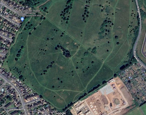
Figure one: Image of site showing allotments and adjacent site under construction 2023
1. Introduction
This development brief sets out Wyre Forest District Council’s vision for the land located west of the former school site at Coniston Crescent, Stourport-on-Severn, which is allocated for housing under site allocation policy SA.S6 of the Wyre Forest District Local Plan The Council have high design aspirations for the site that meet the objectives highlighted in our Local Plan, Design Amenity and Shopfronts SPD and other policy documents. The site offers up a fantastic opportunity to bring forward a high-quality residential site that restores, supports and enhances biodiversity, the wider Green Infrastructure network and improves connectivity to the open countryside for the existing community that surrounds the site.
The site is just over nine hectares in size and is a greenfield site adjacent to the Burlish Country Park (Policy SP.28), which falls within the West Midlands Green Belt. The site will contribute to a vibrant, attractive, well designed, healthy and sustainable place, meeting the housing needs of the local community.
Purpose of the development brief
The purpose of the brief is to provide design principles and planning guidance to developers that should enable the creation of a desirable and sustainable development and that supports the Council’s aspirations whilst not limiting the creativity of developers. The design principles are underpinned by the National Planning Policy Framework and the Wyre Forest Local Plan (2016-2036).
The Vision
The development of the Kingsway site should deliver;
- the creation of an attractive and sustainable medium density development, adjacent to the settlement boundary of Stourport-on-Severn, Stourport High School, Burlish Park Primary School, community allotments and Stourport Sports Club, that creates a strong sense of place complimenting the local vernacular and integrating sensitively with the existing community and its prominent setting on the edge of Stourport and the nature reserve;
- a focus on enhancing existing green assets on the site which will provide a distinct character for the development to create an exemplar landscape led development;
- a mix of well-designed and energy efficient homes of different types, sizes and tenures to help meet current and future local housing needs;
- provide safe and attractive pedestrian/cycle links across and from the site to key facilities in Stourport as well as links to the nature reserve and the national cycle network;
- providing well-connected multi-functional use green spaces, providing benefits to people and wildlife in terms of informal recreation, amenity and biodiversity interest and opportunities for sustainable drainage;
- the provision of a safe and suitable vehicular access and the safe operation of the surrounding local highway network;
- provide a robust green buffer to Burlish Country Park boundary, which will help provide a new sensitive settlement boundary and safeguard the Green Belt from future urban sprawl and encroachment into the open countryside; and
- create a healthy place and flourishing community.
The site lies on the northern side of Stourport-on-Severn, adjacent Burlish Country Park and close to the Burlish Park Primary School, Stourport High School and Stourport Sports Club. The site is adjacent to both existing residential development (Burlish Park estate) and a new housing development on the site allocated for housing under Policy SA.S13 (which is currently under construction) on the edge of Stourport-on-Severn close to the A451 and there is a grade two listed building one kilometre away.
Figure two shows the site and immediate surrounding amenities in more detail.
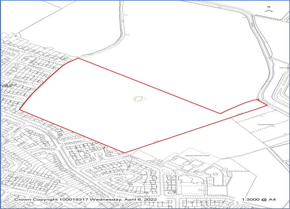
Figure two: Red line drawing showing site allocation and surrounding amenities
The Policy Context
National Planning Policy Framework (NPPF)
The development should reflect the relevant paragraphs of the NPPF “Achieving well-designed and beautiful places” (NPPF, February 2025). In particular, the development should consider para 135 and reflect these aspirations in the design;
- will function well and add to the overall quality of the area, not just for the short term but over the lifetime of the development;
- are visually attractive as a result of good architecture, layout and appropriate and effective landscaping;
- are sympathetic to local character and history, including the surrounding built environment and landscape setting, while not preventing or discouraging appropriate innovation or change (such as increased densities);
- establish or maintain a strong sense of place, using the arrangement of streets, spaces, building types and materials to create attractive, welcoming and distinctive places to live, work and visit;
- optimise the potential of the site to accommodate and sustain an appropriate amount and mix of development (including green and other public space) and support local facilities and transport networks; and
- create places that are safe, inclusive and accessible and which promote health and well-being, with a high standard of amenity for existing and future users; and where crime and disorder, and the fear of crime, do not undermine the quality of life or community cohesion and resilience.
Building for a Healthy Life
The development should consider the 12 considerations included within the Building for a Healthy Life guidance along with the ten characteristics shown in figure three.
Particular consideration should be given to the interaction with nature given the edge of settlement location of the site and proximity to the wider open countryside and nature reserve and important role this site can have in enhancing nature whilst also creating safe, social and inclusive public spaces to benefit residents of the site and wider community.
The potential developers should consider Natural England’s Green Infrastructure Planning and Design Guide (2023) and the wider Natural England’s National Green Infrastructure Framework which complements the National Model Design Code, National Design Guide and the Building with Nature Accreditation.
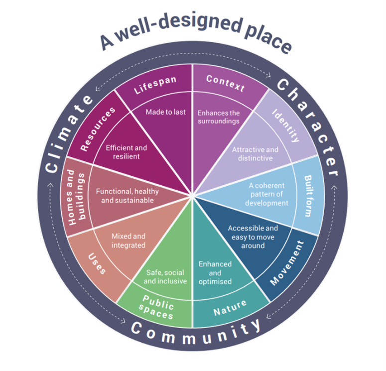
Figure three: the National Design Guide characteristics of a well-designed place
Healthy Places
The site should make a contribution to improving the health and wellbeing of its residents and visitors. This can happen through improving the environment through a number of measures including reducing hazards such as air pollution, having safe and dedicated infrastructure to support active travel routes and opportunities for physical activity, having protective factors included in the design of buildings and environments to help address people’s needs throughout their life. By having well designed and safe indoor and outdoor spaces we can support mental health. The site should make the most of it’s location and ability to provide access to nature as well as providing opportunities to growing food through a community orchard and supporting access to the allotments. The contribution to health and wellbeing can also happen through having a range of house types that can support an inclusive community as well as having homes that are adequately ventilated and heated to reduce respiratory and other related health conditions.
Local Plan (2016 – 36)
This site forms one of several allocated housing sites outlined in the council’s Local Plan. Figure 4 below shows the various development sites allocated within the Local Plan for Stourport on Severn.

Figure four: Local Plan (2016-36) site allocations including SA.S6 (WFDC Local Plan)
This site is allocated for housing (with an indicative capacity of 200 dwellings) in the Local Plan and any development should meet the requirements outlined in the site specific allocation Policy SA.S6 shown below at figure 5.
This site is allocated for residential development which should meet the following requirements:
- Vehicular access should be taken from the Kingsway adjacent to the allotments
- The potential to provide parking for the allotment users should be investigated as part of any proposal and incorporated in the development where feasible
- Opportunities for pedestrian links from the site to existing residential developments should be explored to aid permeability and incorporated in the development where feasible
- A substantial landscaping buffer should be provided along the northern edge to form a new Greenbelt boundary
- The layout of the development should take into account the development site to the east and impacts on surrounding land uses
- Potential to recreate an area of acid grassland on site should be investigated and incorporated into the development where feasible
Figure five: Policy SA.S6 Land west of former school site Coniston Crescent
Other relevant policies
Within the Local Plan and Supplementary Planning Documents (SPDs) there are other relevant policies that need to be taken into consideration in bringing forward development on the site summarised below.
A desirable place to live and the Housing SPD
The site should include a mixture of tenures, types and sizes of accommodation to meet current and future housing needs of the district. There will be a policy requirement to provide a minimum of 25% affordable housing on the site (65/35 split primarily social rented/shared ownership), bungalows and if the development exceeds 50 dwellings then there would be a policy requirement to provide custom and self- build units in line with Local Plan. The council is interested in exploring opportunities with the developer / Registered Provider to bring forward properties for private rent that the council will retain and manage.
Any private rent scheme (PRS) would need to accord with Policy SP.10 of the Local Plan which requires development proposals to offer a mixture of houses at market rent and Affordable Private Rent, aimed at lower to middle income households. In addition, PRS will be required to offer security of tenure through tenancy agreements of 3 years of more, where possible.
A unique place, SP.20 and DM.24 Quality Design and Local Distinctiveness and the Design, Amenity and Shopfronts, SPD
The development must consider the requirements of Policies SP.20 and DM.24- Quality Design and Local Distinctiveness and ensure the development exhibits high quality design that integrates effectively with its surroundings, in terms of form and function, reinforce local distinctiveness through ensuring the design represents a positive addition to the streetscape or landscape.
Biodiversity and Green Infrastructure
The development must consider the relevant policies within the Local Plan including Policy SP.23 alongside Biodiversity Net Gain requirements as set out in the Environmental Act 2021. Ecological assessments must be undertaken and proposals for the management and monitoring of any features retained and enhanced on the site and any created off-site. The development will be expected to directly deliver Green Infrastructure (GI) as part of their design of 40% GI (excluding private gardens).
Transport and accessibility
The development must consider the relevant policies within the Local Plan including Policy SP.23 alongside Biodiversity Net Gain requirements as set out in the Environmental Act 2021. Ecological assessments must be undertaken and proposals for the management and monitoring of any features retained and enhanced on the site and any created off-site. The development will be expected to directly deliver Green Infrastructure (GI) as part of their design of 40% GI (excluding private gardens). Any Planning Application should also consider the Green Infrastructure SPD (draft), which is out for consultation in June 2025, once adopted.
Flood risk management and Sustainable Urban Drainage Systems (SuDs)
The development must be in accordance with Policies SP.31 and 32 and will need to take account of the latest versions of the Strategic Flood Risk Assessment, the Worcestershire Local Flood Risk Management Strategy, and the Worcestershire Surface Water Management Plan. The design and development of the site's surface water drainage scheme should include assessing the potential for management of surface water to be wholly or partially achieved via infiltration. The design and construction of the SuDS should be in line with the non-statutory technical standards for SuDS (Defra, 2015) and WFDC SuDS Design and Evaluation Guide (2017) and a detailed Drainage Strategy will be required that outlines how the proposed drainage system will be managed and maintained for the lifetime of the development. The council’s explicit preference is for the use of aboveground and biodiversity-led SuDS, as detailed in the reasoned justification 14.20 of the Local Plan and the council seeks to avoid underground, engineered and habitat poor SuDS solutions on this site.
Renewable energy
The site should comply, as a minimum, with the requirements set out in Policy SP.37. This requires that all new developments should consider location, design, siting and orientation to maximise the use of natural heat and light and the potential for renewable energy micro-generation. All new residential should also include electric vehicle charging points. In addition, all new developments of one or more dwellings should incorporate the energy from renewable or low carbon sources equivalent to at least 10% of predicted energy requirements.
Open space / play provision
The site should comply with Policy DM.8 provision for open space, sports pitches and outdoor community uses in housing developments. The site will require either two local areas for play (LAP) at 100sqm per LAP or one Local Equipped Play Area (LEAP) and this should include inclusive play equipment and a small low key games area. The council’s preference is for the development to have one LEAP located in the northwestern corner of the site allocation.

Figure six: Play area on adjacent development site
There is currently a Local Equipped Play Area (LEAP) facility located within the former Stourport High School grounds which is currently being redeveloped for housing (Site Allocation Policy SA.S13).
Health Supplementary Planning Document and Health and Wellbeing Policy (SP.16)
The Health and Wellbeing SPD requires that major development sites undertake a full Health Impact Assessment to understand the effects of the proposal on different population groups and consider how the impacts could be mitigated through the design and layout of the site in line with Policy SP.16 of the Local Plan. Developments should help minimise negative health impacts and maximise opportunities to ensure that people in Wyre Forest District lead healthy, active lifestyles and experience a high quality of life including through safe and attractive public realm, green infrastructure and spaces that enable formal and informal physical activity, recreation and play, and should support healthy living and social cohesion. They should include access to health service provision and encourage access to fresh locally grown food. Homes should be high quality, energy efficient, affordable and adaptable that meet the needs of different groups in the community, including older people and those with disabilities.
There are other sections of the Local Plan that should also be considered in bringing forward a proposal for this site.
|
Policy |
Detail |
|---|---|
|
SP.22 |
Landscape Character The site should consider SP.22 including;
|
|
SP.23 |
Protecting and Enhancing Biodiversity The site should consider SP.23 including;
|
|
SP.27 |
Transport and Accessibility in Wyre Forest The site should consider SP.27 including;
|
|
SP.28 |
Green Infrastructure The site should consider SP.28 including;
|
|
SP.29 |
Water Conservation and Efficiency The site should consider SP.29 including;
|
|
SP.30 |
Sewerage Systems and Water Quality The site should consider SP.30 including;
|
|
SP.35 |
Waste
|
|
DM.26 |
Landscaping and Boundary Treatment
|
3. Site survey and analysis
3.1 Site location
The site is located in a sustainable location on the edge of the town of Stourport-on-Severn and is highly accessible to primary and high schools, sports centre, convenience stores, a nature reserve and parks.
The town has a population of just over 20,000 (Census 2021). It is a popular visitor destination attracting people to its historic canal basins, as it was once a large inland port, to the River Severn and to the fun fair located in the town centre.

Figure seven: This shows the site in relation to Stourport and its amenities (Google Maps 2024)


Figure eight: Images of Stourport on Severn historic canal, Bridge Street and the Fun Fair (Google Images accessed 18/06/2024).
3.2 Site opportunities and constraints
3.2.1 Site opportunities
Meeting Housing Need
The site provides an opportunity for the council to meet a variety of housing needs on the site including differing sizes and tenures. The council is keen to work with developers who would consider a joint venture with the council to meet their aspiration of bring forward high quality private rented accommodation as well as affordable housing and owner occupation. There are currently over 450 households on the housing register waiting for affordable properties in Stourport. This scheme should address these housing needs through the provision of different sizes of family housing (2, 3 and 4 bedroom) with the greatest demand for two bedroom properties. Some accommodation that is suitable for single people and childless couples should also be included along with some minimal requirements for older or disabled people such as one bedroom houses and bungalows. The most appropriate housing mix will be determined at the planning application stage based on the most up to date information available.
Design
The prevailing character of the local area comprises houses arranged around short cul-de-sac roads, set on linear building lines with a direct road frontage. Corner houses are often given a spacious plot to provide open aspects to road junctions and there is limited or no front boundary treatments. The surrounding area also comprises mainly two-storey dwellings with small groups of bungalows. Parking provision is provided on plot within the local area.
The development should provide a high quality housing development that embraces vernacular architectural styles and layout to reinforce the sense of place and enhance the local character. The design of the development should consider using landform, layout, building orientation, tree planting, massing and landscaping to reduce energy consumption and increase resilience to increased temperatures.
Landscape
There is an opportunity to work with the mature landscape setting of the site to create a sense of place and a sensitive development that provides a landscape buffer to the new Green Belt boundary that strengthens the green infrastructure network in this part of the district Any development on the site will be required to provide street trees within unadopted grass verges and outside of residential plots.
Walking and cycling connections
The development should ensure it maximises the opportunities to improve sustainable modes of travel including cycling and walking connections through the area with reference to accessing the local schools, bus provision, nature reserve, national cycle route and sports centre cycle track, existing amenities and connectivity with surrounding settlements. Although there are no formal public rights of way the site is accessible to the public and a number of walking routes have already been established across the site to the adjacent nature reserve and open countryside.
Open space and multi-functional green infrastructure
There is an opportunity to create new multi-functional open spaces and green infrastructure in the area that will provide safe and functional informal recreation opportunities for both existing and local residents and also enhance wildlife habitats and provide SuDS.
3.2.2. Site constraints
Flooding
The site is located within Flood Zone one and so flooding is likely to be a low risk. However, all developments will need to be designed to ensure there is no increased risk of flooding elsewhere.

Figure nine: Flood map for the site (Environment Agency, 2024)
There is some risk of surface water flooding in the east and southeast corner of the site. Please see figure ten below.

Figure ten: Surface water flood risk
The developer will need to consider the treatment of the run-off from the roads, hard surfaced areas and buildings and undertake an assessment utilising the simple index approach (SUDS manual, CIRIA). The developer should consider what other mitigation measures could be incorporated into the site to tackle the effects of climate change.
Listed Building and Conservation Areas
The site does not fall within a Conservation Area and does not include any listed buildings. The nearest listed building is located some distance away on the other side of the A451.
Existing landscaping features, Biodiversity and Tree Preservation Orders
The site has a number of individual trees and a raised, tree capped area in the central/eastern part of the site that should be integrated into the design. There are currently no trees subject to a TPO.
In terms of protected and notable species, the site is likely to have reptiles, badgers, hedgehogs and ground nesting birds. There is a lower likelihood of bats, amphibians, owls or dormice but a Preliminary Ecological Assessment will need to be undertaken.
There will be a requirement to meet the Biodiversity Net Gain requirement and this should be considered on the existing site first and then on the adjacent nature reserve as this is a council-owned site subject to robust justification.
There would be a requirement to undertake buffering and improving the quality and connectivity of local nature reserves.
Sensitive edges with existing houses
There are existing residential properties on the northern and western boundaries and a new build development on the southern boundary to the site. Along the western and southwestern boundary some of the residential properties open onto the site with minimal boundary separation and so consideration will need to be given to screening and separation distances.

Figure eleven: Properties adjacent to site (KB 10/04/2024)
Landscape Character Assessment
The site falls within the Sandstone Estatelands Landscape Character Type by Worcestershire County Council. This is defined as an open, rolling landscape characterised by an ordered pattern of large, arable fields, straight roads and estate plantations. The overall management strategy is to conserve and enhance the structure and wooded character of the landscape.
The site is identified by the Natural England National Character Area as Area: 66 - Mid Severn Sandstone Plateau and offers a unique opportunity to restore acid grassland including by reinstating appropriate levels of grazing where possible and encouraging the restoration of hedgerows and orchards with typical species.
The development site should therefore consider the planting of additional woodland through inclusion of an orchard, street trees and hedgerows as well as considering the restoration of acidic grassland to the site.
Access to the site
The Local Plan proposes vehicular and pedestrian access to the site from the Kingsway adjacent to the allotments. There would be a requirement of displacement allotment car parking spaces, provision of new footpaths on Kingsway and any loss to habitat would need to be mitigated and enhanced by 10% through creating access. An alternative access onto the site could be from Buttermere Road and Ullswater Avenue and the precise form and location of site access should be agreed with the Highways Authority prior to the submission of any planning application.
Topography
The land consists of gently sloping areas rising in the northern part of the site and a high point located in the central/eastern part of the site capped with trees. There is a change in level of approximately 10 metres across the site.
Utilities Infrastructure Capacity
There are no known constraints from existing utilities running across the site. Additional work would be required with the utility providers to identify if there are any constraints based on existing capacity. If reinforcement works are required these will be at the developers’ expense.
4. The development brief
4.1 Land uses and layout
The site lends itself to four or five distinct areas of housing along the southern, western and northern boundaries of the site and distinct areas of green infrastructure, which are shown below in Figure 11 in green, including to maintain the prominent feature of the site topped with trees and to create a landscape buffer adjacent to the existing residential area to the southwest and to the Green Belt boundary. The significant footpaths across the site should be preserved where possible to ensure permeability and connectivity with the wider open countryside. The residential area to the southwest of the site should provide good separation from the site boundary and avoid overshadowing from existing mature trees.

Figure twelve: Green infrastructure, play area and buffer (Local Plan 2022)
The site will need to provide a mix of house types, sizes and tenures in order to help meet varied housing needs in the local area, and to create variation and choice within the development and to support social inclusion and sustainable communities. The council will expect a range of different dwelling types to meet evidenced affordable housing needs, as well as bungalows and self and custom build plots.
This should include houses, a minimum of 5% bungalows and two storey flats as part of the overall mix. There should be a contribution of a minimum of 25% affordable housing, custom and self-build units and disabled adapted units in line with Chapter Seven of the Local Plan and the Housing SPD and these will be distributed through the scheme in small clusters.
The council is also keen to work, through a joint venture or similar arrangement, around the provision of private rented sector accommodation for the council to retain.
4.2 Typology of proposed buildings, density and building heights
The site should reflect the surrounding vernacular in terms or heights and density as well as meet housing needs and deliver 1 – 2.5 storey houses, flats and bungalows. The expected density is a minimum of 35 units per hectare. In terms of building heights lower rise dwellings should be located on the higher part of the site shown in figure 12 below in purple and along the northwestern boundary. The development should include a more linear front building line set back from the road facing the new housing development on the southwestern boundary and more feathered out and organic near to the northern boundary.

Figure thirteen: Stourport on Severn and the development site (Local Plan 2022)
The surrounding area is made up of a combination of terraced, semi-detached and detached houses and a low number of bungalows and reflects the medium density anticipated on this site.

Figure fourteen: Images from the surrounding areas (KB 30/05/2024)
4.3 Access and movement
Figure fourteen below shows the potential points of access to the site for pedestrians and cyclists (red and blue) and for vehicles (black), as established in the Local Plan. The site should have a well-connected, permeable network across to the existing residential areas and to the nature reserve with a hierarchy of streets. Developers should consider access into and through the site in terms of both vehicular and active travel modes.
There should be a balanced approach to meet the needs of all users, prioritising the safety of pedestrians and cyclists. There should be active frontages along movement routes to ensure safe and overlooked streets and paths and there should be the appropriate lighting of routes balancing safety with the need to minimise light pollution.

Figure fifteen: Potential and existing points of access (Local Plan 2022)
4.3.1 Vehicles
Vehicular access, parking and permeability across the site should have regard to the principles and design criteria set out in Manual for Streets 1 and 2, the Worcestershire Local Transport Plan compendium and the Worcestershire Streetscape Design Guide. Residential streets should be designed to limit traffic speeds to 20mph.
Parking should be well integrated so that cars don’t dominate the street scene including a mix of well-designed parking arrangements (e.g. garages and on-plot). If courtyard parking is included it must be overlooked and have an active pedestrian route through.

Figure sixteen: From WFDC Design, Amenity and Shopfronts SPD (2024)

Figure seventeen: Example of courtyard parking (Google Images accessed 2024)
The layout should be conducive to encouraging the use of public transport including the existing bus routes in Windermere Way and the provision of safe route between homes and public transport. The Developer will need to explore public vehicular access from the site to the road network via the Kingsway and/or Windermere Way onto the A451.
4.3.2 Pedestrians and Cyclists
The layouts and routes should be easy to “read” and navigate around and where possible active travel routes should be separate from roads. Consideration must be given to safe pedestrian and cycle routes across the site, with natural surveillance and interlinking with the existing cycle and footpaths into the existing residential area including the new development and the nature reserve. The cycle route should connect, if possible, across the country park to the national cycle route 45 and the cycle route within the Windermere Grange development. Please see figure 17 for examples of inappropriate and appropriate footpaths.

Figure eighteen: Example of footpaths from North of Sycamore Close, Endmoor SPD
4.4. Views in and out
A wide landscape buffer should be provided along the northern boundary of the site to provide a defensible new green belt boundary and help soften the impact of the development on the wider open countryside and landscape. The eastern and southern parts of the site are on lower ground and partially concealed by the slope at the western boundary of the nature reserve enabling it to be partly screened and development should broadly take place in these areas.
The view from the site, facing southwest, across to the Abberley Hills should be preserved.

Figure nineteen: View across the nature reserve towards north-western part of the site (KB 10/04/2024)

Figure twenty: view across the nature reserve to the site and the new Windermere Grange development (KB 10/04/2024)

Figure twenty one: view across nature reserve to eastern boundary of the site (KB 10/04/2024)

Figure twenty two: view across nature reserve to higher ground on eastern boundary of the site (KB 10/04/2024)

Figure twenty three: view towards south-western part of the site (KB 10/04/2024)
4.5 Green infrastructure and open spaces
There is a Local Plan requirement of 40% green infrastructure on the site and it should be designed to include a defensible boundary to the greenbelt and creating a buffer to the existing residential area. All existing mature trees on the site should be retained (in line with Policies SP.23, SP.28 and DM.26) and the internal roads should have non-adopted grass verges with street trees included.

Figure twenty four: Image of a street tree (Green Infrastructure Panning and Design Guide page 42)
Existing trees and boundary scrub adjacent to the site should be protected during the construction period and beyond through the use of buffer zones. The primary viewpoint of the central raised tree-capped hill on the site must be preserved. The council would welcome enhancements to the landscape including through the restoration of hedgerows and acidic grassland, an orchard and additional tree planting. This would help to bring greater variety and diversity to the site. The development should incorporate wildlife friendly features such as bird and bat boxes, hedgehog hole fencing and habitat piles. Innovate designs that combine practicality with supporting biodiversity should be considered, for example combining bin stores with bug houses as shown in figure twenty five below. Open spaces must be safe, secure and accessible.

Figure twenty five : Image of bin store (Green Infrastructure Panning and Design Guide page 44)
The Developer should explore opportunities to work with the council who currently maintain the land including through grazing of on-site public open space to increase the biodiversity net gain of the sward within the site.
There will be a requirement to provide a play area(s) either as two LAPS or one LEAP and it is considered more appropriate to provide one LEAP next to the northeast boundary (see red block) on Figure 11 and away from the new LEAP that has been provided on the former High School’s playing fields as this would benefit both existing and new residents.
The site should be suitable for infiltration SuDS as the Soilscape is “Freely draining slightly acid sandy soils” https://www.landis.org.uk/soilscapes/. We would encourage the incorporation of rain gardens and swales/ponds. The use of infiltration SuDS will ensure that following development no additional runoff will leave the site and therefore that the development will not exacerbate flooding elsewhere. We would expect the developer to initiate early engagement with Highways regarding the type of SuDS that will be acceptable to them for the disposal of surface water from any roads that are intended for adoption and any adopted road must comply with the Streetscape Design Guide.

Figure twenty six: Example of raingardens (Google Image 30/05/2024)

Figure twenty seven: Example of a swale on the adjacent nature reserve (KB 10/04/2024)
4.6 Design and materials
The key design principle of the Abberley Hills site is the creation of an attractive and sustainable residential development that is sympathetic to the local context and particularly the adjacent nature reserve. Design cues should be taken for the area’s local vernacular (aspects such as mixed brick and render dwellings found in the local housing types), including materials, features, detailing etc to create a distinctive development with variations in house types and styles.

Figure twenty eight: Examples of brick and render buildings (Google Images 18/06/2024 and KB 30/05/2024)
The scheme should incorporate landmark buildings or design features at focal points and at main access and intersections to help provide legibility through the neighbourhood and visual interest.

Figure twenty nine: Examples of brick and render landmark buildings (Google Images 18/06/2024)
The scheme should incorporate hedgerows to the front boundaries of properties to support the ambitions for the site based on the landscape character.

Figure thirty: Examples of properties incorporating hedgerow to the front garden (Google Images 24/06/2024)
The Developers should consider the orientation of properties and having eaves that overhang the South facing elevation so that habitable rooms are on the north side and rear gardens are south facing.
4.7 Environmental Sustainability
In terms of housing technical standards, any planning application decisions on the site will be subject to standards set within Local Plan and relevant national policy. Under the current adopted Local Plan policy new residential development will be required to provide electric vehicle chargepoints and new development of this scale should incorporate the energy from renewable or low carbon sources equivalent to at least 10% of predicted energy requirements. The council will encourage development that promotes higher standards of sustainable construction and renewable energy provision to help mitigate against the affects of climate change and reduce the costs of running a home.
5. Conclusion and next steps
The Abberley Hills site provides the council with a unique opportunity to bring forward an attractive, healthy and sustainable development, adjacent to the existing residential areas of Stourport-on-Severn that creates a strong sense of place complimenting the local vernacular and integrating sensitively with the existing community, the Country Park and this part of the Green Belt. It is important that the site is resilient to climate change, enhances the landscaper character and biodiversity of the site and supports access to the adjacent nature reserve.
The council will consult with key stakeholders and residents in relation to the Development Brief and further consultation undertaken by the Developer should be in line with the council’s Statement of Community Involvement.
The council is keen to include a wide range of tenures and types of housing on the site and to this end are seeking a Developer interested in bringing forward this site in conjunction with the council that includes an element of private rented accommodation that the council will retain.
References
Figures / images
housing estate with courtyard parking - Google Search
housing brick and render design UK - Google Search
images of stourport on severn canal - Google Search
Bibliography
Healthy Places – How Urban Design and Planning can support good health outcomes David Lock Associates, Office for Health Improvement and Disparities and Sport England (2023)
Websites
National Character Areas (June 2024). Accessed at https://nationalcharacterareas.co.uk/mid-severn-sandstone-plateau/statement-of-environmental-opportunity
Landscape Character Assessment. Accessed at Landscape Character Assessment | Worcestershire County Council (April 2024)
Natural England Green Infrastructure Planning (2023). Accessed at Natural England Green Infrastructure Planning and Design Guide 2023
National Planning Policy Framework (Dec 2023). Accessed at National Planning Policy Framework - GOV.UK (www.gov.uk)
Wyre Forest Local Plan (April 2022). Accessed at Wyre Forest District Local Plan (2016-2036) - Adopted April 2022 - Keystone (objective.co.uk)
Building for a Healthy Life guidance (June 2020). Accessed at BFL-2020-Brochure.pdf (designforhomes.org)
Natural England’s National Green Infrastructure Framework (January 2023). Accessed at Green Infrastructure Home (naturalengland.org.uk)
National Model Design Code (July 2021). Accessed at National Model Design Code - GOV.UK (www.gov.uk)
National Design Guide (October 2019). Accessed at National design guide - GOV.UK (www.gov.uk)
Building with Nature Accreditation. Accessed at Building with Nature. July 2024.
North of Sycamore Close, Endmoor SPD (August 2017). Accessed at Development brief North of Sycamore Close, Endmoor (southlakeland.gov.uk)