
Bewdley Conservation Area Character Appraisal
March 2026
The draft conservation area character appraisal consultation is now closed.
Contents
2.0 Legislative and policy framework
3.0 Management plan
4.0 Analysis of character
5.0 Conclusion
This appraisal concerns the Bewdley Conservation Area, located in the town of Bewdley, Worcestershire. The Conservation Area was first designated in 1968 and subsequently reviewed in 1976. It extends across approximately 42.8 hectares (105.7 acres) and includes the town centre, adjoining residential streets, sections of the River Severn and its riverfront landscapes, as well as part of the historic settlement of Wribbenhall. The built character largely reflects development from the fifteenth to nineteenth centuries, although the origins of settlement in the area are earlier.
Comments within this appraisal cover both Enhancement Sites and Neutral Sites, which provide a snapshot of conditions at the time of writing, while other observations on the overall character of the Area are intended to remain more enduring.
A map at the end of this document illustrates the Conservation Area boundary along with key features referenced in the text.
2.0 Legislative and policy framework
The legal definition of a Conservation Area is set out in Section 69 of the Planning (Listed Buildings and Conservation Areas) Act 1990 as:
“an area of special architectural or historic interest, the character or appearance of which it is desirable to preserve or enhance.”
Under this legislation, local planning authorities have a duty to designate areas which meet this definition and to ensure that their special character is protected through the planning process.
Section 72 of the Act places a further statutory duty on local planning authorities, requiring that in the exercise of planning functions within a Conservation Area:
“special attention shall be paid to the desirability of preserving or enhancing the character or appearance of that area.”
This duty is central to the planning system’s approach to the historic environment. It requires decision-makers to give careful consideration to the impact of development proposals on the character and appearance of a Conservation Area and to ensure that these qualities are preserved or enhanced wherever possible.
The meaning of “preserve” in this context has been clarified through case law. The courts have established that preservation does not necessarily require improvement; development which leaves the character or appearance of a Conservation Area unharmed can be considered to preserve it. At the same time, the courts have made clear that greater care and stricter control over development is expected within conservation areas than elsewhere.
More recent judgments have reinforced the importance of the statutory duty. In particular, the courts have confirmed that decision-makers must give considerable importance and weight to the desirability of preserving or enhancing the character or appearance of a Conservation Area when determining planning applications.
National planning policy supports this legislative framework. The National Planning Policy Framework recognises the historic environment as an irreplaceable resource and requires that heritage assets, including Conservation Areas, are conserved in a manner appropriate to their significance. Great weight should be given to the conservation of designated heritage assets when considering development proposals that may affect them.
The National Planning Policy Framework also emphasises that the significance of heritage assets can be harmed or lost through inappropriate development within their setting or through alterations that fail to respect their historic character. As such, proposals affecting Conservation Areas should demonstrate a clear understanding of their significance and respond positively to the qualities that justify their designation.
Historic England provides further guidance on the designation, appraisal and management of Conservation Areas. This guidance encourages local planning authorities to prepare detailed appraisals in order to identify the features which contribute positively to the special interest of each area. By clearly defining these characteristics, conservation area appraisals provide an important framework for managing change and ensuring that future development respects the historic environment.
This appraisal therefore seeks to identify and describe the key elements which contribute to the special architectural and historic interest of the Bewdley Conservation Area. In doing so, it provides a clear basis for the careful management of change within the area and will inform future planning decisions, conservation policies, and potential measures such as boundary reviews, Article 4 Directions, design guidance, and enforcement action where appropriate.
3.0 Management plan
The Bewdley Conservation Area possesses considerable architectural and historic significance, reflecting the town’s development as an important crossing point of the River Severn and a prosperous centre of trade from the medieval period through the Georgian period. The quality and coherence of the townscape, together with the close relationship between the built form, the river, and the surrounding landscape, give the area a distinctive and recognisable character. The continued preservation and enhancement of these qualities should therefore remain the principal objective of future management.
The majority of buildings within the Conservation Area remain in good or fair condition and continue to contribute positively to its historic character. However, there remain opportunities to enhance the area where modern alterations, intrusive materials, or unsympathetic developments have eroded the historic qualities of the townscape. Addressing these issues gradually through careful management and sensitive redevelopment will help reinforce the architectural integrity of the Conservation Area and ensure that its special interest is maintained.
One of the more common issues affecting the character of the Conservation Area is the incremental alteration of historic buildings through the introduction of modern materials and features that are not in keeping with their original design. Alterations such as the installation of uPVC windows and doors, inappropriate rooflights, cement-based pointing, and the painting or rendering of previously exposed brickwork can diminish the authenticity and visual coherence of the historic environment. External fixtures such as satellite dishes, modern signage, and other fittings attached directly to historic masonry can also detract from the architectural character of buildings and, in some cases, cause physical damage to the historic fabric. Where opportunities arise, efforts should be made to reverse such alterations and encourage the reinstatement of traditional materials and detailing that reflect the established character of the area.
Commercial frontages within the town centre also present opportunities for enhancement. In some cases, modern shopfronts, fascias, and display windows have been introduced which fail to respect the historic proportions and detailing of the buildings to which they are attached. Over time, the gradual replacement of these features with more sympathetic designs would help to restore the architectural rhythm and visual harmony of the street. Improvements may include the use of traditional materials, appropriate fascia proportions, and detailing that reflects the historic character of the host building and the wider streetscape.
There are also a small number of sites within the Conservation Area that make a neutral or limited contribution to its character. These include certain twentieth-century buildings and utilitarian structures which, while not significantly harmful to the area, do not reflect the historic architectural qualities that define much of Bewdley’s built environment. Should opportunities for redevelopment arise, these locations offer potential for enhancement. Any new development should respond positively to the surrounding historic context through the careful use of appropriate scale, materials, and design.
The public realm plays an important role in shaping the character and appearance of the Conservation Area. Elements such as modern street furniture, signage, and extensive areas of standard tarmac surfacing can detract from the historic setting. Opportunities should therefore be explored to improve the quality and appearance of the public realm over time. This may include the introduction of more sympathetic paving materials, improved lighting columns designed with regard to the historic environment, and the rationalisation of unnecessary signage and street clutter. Any such improvements should be carefully designed to complement the historic character of the town.
The landscape setting of Bewdley is one of its defining characteristics. The relationship between the historic town and the River Severn, together with views towards the surrounding countryside and wooded hillsides, contributes significantly to the character of the Conservation Area. The preservation of these views and the protection of open spaces along the river corridor are therefore important considerations in the management of the area. Mature trees and historic planting also make an important contribution to the character and appearance of the town and should be retained and managed appropriately.
Landscape management may also present opportunities to reinforce the historic character of the area. In certain locations, the reintroduction of traditional planting associated with the riverside environment may help to strengthen the historic setting. Equally, care should be taken to ensure that new planting does not obscure important views or alter the historic spatial relationships between buildings and open spaces.
The updated Conservation Area Appraisal will serve as an important tool in managing change within Bewdley. By clearly identifying the elements that contribute positively to the significance of the area, including its historic buildings, street pattern, public spaces, and landscape setting, the appraisal will provide a framework for assessing future development proposals. This will help ensure that alterations, new development, and public realm works respect the established character of the town in terms of scale, materials, and architectural detailing.
Through careful management, sensitive redevelopment, and the gradual removal of unsympathetic alterations, the special architectural and historic character of the Bewdley Conservation Area can be preserved and enhanced. In doing so, the area will continue to reflect the rich history of the town while remaining an attractive and distinctive environment for residents, businesses, and visitors.
4.0 Analysis of character
4.1 Setting and Topography
Several aspects of the setting and topography, both within and adjoining the Conservation Area, contribute significantly to its character:
a) The Conservation Area occupies the historic core of Bewdley, a town that sits within and is partly screened by unspoilt, undulating countryside. The Area covers a substantial portion of the town and, in some places, adjoins open countryside, making the rural setting an integral part of its character. Much of this surrounding landscape was designated in the Worcestershire County Development Plan of the 1950s as an Area of Great Landscape Value, and successive Local Plans have continued to recognise its high landscape quality. To the west, north, and south lies the Wyre Forest and its associated landscapes, acknowledged as being of national importance for nature conservation. On the opposite side of the River Severn, the urban fringe is entirely designated as Green Belt. Safeguarding this rural setting is essential to conserving the character of both the town and the Conservation Area, with careful attention given to the interrelationship between the Area and its wider landscape context.
The River Severn cuts a broad valley through the centre of both the town and the Conservation Area, forming one of its most defining features. Within this stretch the channel varies between about 40 and 55 metres in width. For much of its length, the riverbanks are faced with natural sandstone blocks, historically forming the town’s quaysides. The river serves to draw the countryside directly into the heart of the town, particularly where the settlement narrows towards the river to the north and south. With only a single bridge crossing within the town centre and Conservation Area, views up and downstream from the bridge and adjoining quaysides remain open, uninterrupted, and strongly connected to the surrounding landscape.
Either side of the river lie natural floodplain terraces or shelves. On the south-west bank the terrace extends for roughly 100 metres, and on the north-east side it is slightly wider. These areas were largely developed before the twentieth century to create the historic town centre, while later development tended to occupy higher ground, encouraging the town to grow east–west rather than along the river terraces. As a result, much of the riverside has remained as open meadows, providing immediate and valuable links between the Conservation Area and the wider countryside. From a conservation perspective, it is important to safeguard these areas from further built development, recognising that the zone of character extends beyond the current Conservation Area boundary to include the meadows and riverside footpaths.
The area of interest also encompasses several historic buildings outside the existing boundary. These include properties along the south-east side of Lax Lane, Mill House (formerly Severnside Mill), Springfield Villas and Springfield Place on Riverside North, and No. 21 Stourport Road. The land and buildings at the south-east end of Riverside North form a visually prominent site and play an important role in the immediate setting. Here, late nineteenth-century buildings such as Springfield Villas and Springfield House integrate reasonably well into their surroundings, whereas three late twentieth-century commercial buildings in the same location appear out of keeping and visually intrusive.
Beyond the river terraces the land rises into a series of small hills, significantly higher than the town centre, which provide a strong sense of natural enclosure to the Conservation Area. Key features include:
East side of the River:
Maypole Piece: This largely undeveloped hill is a highly visible feature, especially from the Severn Valley Railway and from the main eastern approach into Bewdley along Kidderminster Road. It is also prominent in views looking north-east from the central bridge, from the northern end of Lax Lane, Severnside South, and Venus Bank. Despite lying well within the modern town boundary, its open, undeveloped character lends a rural quality to the area and helps to separate the eastern edge of the Conservation Area from later development in northern Wribbenhall.
The upper slopes and the land adjoining the northern edge of the Severn Valley Railway Station are characterised by substantial tree and shrub cover, which enhances both the visual and ecological value of the hillside. By contrast, housing development on the lower western slopes, particularly around Maypole Close, integrates poorly with the character of the Conservation Area.
From a conservation perspective it is important to resist any further built development on Maypole Piece and to ensure that existing vegetation is maintained. The area of character interest here extends beyond the current Conservation Area boundary, particularly across the ridgeline and the adjoining slopes to the south-east and north-east.
Clarence Way/Gloucester Way and The Summer House: This partially developed hillside forms a key link to the open countryside to the north-west and is highly visible from multiple viewpoints, including the Severn Valley Steam Railway, the main eastern approach along Kidderminster Road, the central bridge, the River frontages on the south-west bank, and rising ground to the west such as Venus Bank.
The slopes are densely wooded, predominantly with deciduous species, while scattered along the crest are several specimen conifers planted within the grounds of The Summer House, a large, isolated period property that occupies a prominent position on the skyline. Late twentieth-century housing on the eastern side of the slope contrasts with the historic character and integrates poorly with the surrounding landscape.
From a conservation perspective, it is important to maintain the undeveloped nature of the crest and western slopes, as well as the direct visual and physical link to the open countryside to the north-west.
 Wooded hilltop associated with the Summer House, from Severnside South, with Beales Corner to the fore.
West side of the River
Venus Bank and Patchetts Hill: This hillside, located to the north-west of the Conservation Area, is partially developed. Development on the lower and middle slopes of Venus Bank generally integrates well with the character of the Area, with many buildings following historic plot patterns and reflecting the scale and style of older properties. By contrast, housing on the upper slopes (particularly off Church View and Woodthorpe Drive) has been less successful in blending with the historic character. Modern houses on Church View appear conspicuous on the skyline when viewed from key vantage points, including the central River bridge.
 Venus Bank viewed from the central bridge
From a conservation perspective, it is important to preserve the remaining undeveloped land at the south-east end of Church View and off Richmond Road, and to prevent further infill or intensification across the hillside. The area of character interest at this location extends beyond the current Conservation Area boundary to include the undeveloped land at the end of Church View, which contributes significantly to the wider setting and should be retained in its natural state.
Vegetation and Parkland: Mature vegetation is an important element of the Conservation Area’s setting and can be seen from a number of vantage points, including the railway station at Wribbenhall, the public car park off Lax Lane, riverside walks, and in views south-east along High Street. These wooded areas link with the historic parkland and gardens of Kateshill House and Winterdyne House, the latter being recognised by the Hereford and Worcester Gardens Preservation Trust as a site of local importance.
The area is characterised by a wide variety of trees, hedgerows, shrubs, and ornamental planting, all of which contribute significantly to its visual interest and landscape character. A further distinctive feature is Red Hill, the narrow road leading to the hamlet of Ribbesford, which for a short section is cut directly into the sandstone bedrock. This cutting is a notable characteristic of the area and adds to its historic and scenic quality.
From a conservation perspective, it is important that this area remains free from further built development, that the existing vegetation is preserved, and that the distinctive character of the roadway is maintained. At this point the area of character interest extends beyond the present Conservation Area boundary, particularly to include Winterdyne House and its associated parkland.
Winbrook: This twisting gully, with a road running along its base, forms the main approach into and out of the western side of the Conservation Area. Its steep slopes and the gradient of the road create a strong sense of enclosure and movement. Although now within the town boundary, the gully sides retain undeveloped areas both inside and beyond the Conservation Area, which contribute to a distinctly rural character. A narrow, winding footpath runs along the upper northern slope, linking land within the Area to that beyond its boundary.
Retention of these undeveloped areas is important, and they could be considered for designation as Urban Open Space. Several historic buildings and plots of interest also lie just beyond the current boundary in this location, and their preservation is desirable. The area of character interest here therefore extends beyond the Conservation Area, particularly to include the older buildings and open land adjoining the footpath north of Cleobury Road (between the footpath and Cleobury Road) and stretching westwards to the junction with Merricks Lane.
Later expansion of the town: The historic core of Bewdley has expanded over time with suburban development on both sides of the River predominantly along an east–west axis. To the west, this growth largely occurred during the twentieth century, while to the east it took place during the nineteenth and twentieth centuries. On the eastern side, the area of character interest extends beyond the current boundary to include buildings along both sides of Kidderminster Road, culminating with All Saints Church. Further east, a group of mid-nineteenth-century dwellings located at the south-west end of Habberley Road and along the Kidderminster Road form an important historic gateway corridor into the town.
4.2 Historic Evolution
The Conservation Area encompasses the historic core of Bewdley and its adjoining landscape. While prehistoric and Roman artefacts have been discovered here, the surviving built fabric dates largely from the medieval period onwards.
Bewdley itself is not mentioned in the Domesday Survey of 1086, although Wribbenhall appears under the name “Bailiwick,” recorded as part of the manor of Kidderminster. The earliest surviving reference to Bewdley, then called “Beaulieu,” dates from 1304, when it was associated with a manor on the west bank of the River Severn.
The town’s location has long been shaped by its role as a key crossing point of the Severn, a factor likely central to its origins. A ford probably existed here from an early date, followed by a ferry service first documented in 1336. The first bridge was built in 1447.
During the late 14th and 15th centuries Bewdley expanded, with ferry profits increasing and the number of free tenants rising steadily. The first burgage was recorded in 1367, and in 1376 permission was granted for a market on Wyre Hill. By the mid-15th century, a marketplace had been established in Load Street. Around this time the settlement evolved from a linear village along Wyre Hill and the ford approach into a planned town with a chapel (c.1450) in Load Street, laid-out streets, and gates (now lost). Bewdley’s prestige was enhanced in the 16th century by the presence of Tickenhill, a royal palace built by Henry VII for his son Arthur, where the Court of the Marches often spent summers. A number of timber-framed buildings from this period survive.
The timber bridge of 1447 was rebuilt in 1460, and replaced with a stone bridge in 1483, which remained until the current bridge was constructed in 1798.
By the late medieval and early modern periods, Bewdley had grown into a prosperous inland port, facilitating trade between the Upper Severn Valley, the Black Country, and Bristol. The town also became a focus for nonconformist religious groups, many of whom established chapels tucked away from the main streets in accordance with restrictions of the time.
As a market and trading centre, Bewdley supported a wide variety of crafts and industries including cloth, leather, and rope making. The navigable river and nearby Wyre Forest, rich in natural resources, enabled the town to attract trade well beyond what might be expected for a settlement of its size.
By the mid-18th century, Bewdley ranked as one of the country’s most important inland ports. Its strategic location made it a centre for the trans-shipment of bar-iron and other goods from Wales and the west, either overland to the growing industries of Birmingham or downstream to Bristol. Prosperity at this time was reflected in an impressive building programme: elegant Georgian houses, remodelled façades, and substantial merchants’ residences overlooking the town. Many of these still stand, though often subdivided. While Bewdley’s medieval origins remain visible, Pevsner (writing in the mid-20th century) described it as “the most perfect small Georgian town in Worcestershire,” underlining the enduring significance of this later architectural legacy.
The town’s fortunes declined in the late 18th century with the arrival of canals, particularly the Staffordshire and Worcestershire Canal (c.1771), which created the rival port of Stourport-on-Severn just a few miles south. Thereafter Bewdley remained a market town but lost its wider trading importance. The arrival of the railway in the mid-19th century, linking Wribbenhall with Kidderminster and Bridgnorth, did little to reverse this. Unlike many towns, Bewdley largely escaped extensive Victorian redevelopment. With reduced commercial activity, it retained much of its historic form into the 19th and early 20th centuries, helping preserve its architectural character.
The town is also notable as the birthplace of Sir Stanley Baldwin, later Earl Baldwin of Bewdley, who served as Prime Minister three times in the early 20th century. His birthplace, 15 Lower Park, still survives, though now divided into flats.
In the later 20th century, the introduction of modern planning controls coincided with substantial suburban growth around both Bewdley and Wribbenhall, much of which failed to integrate with the historic townscape. In 1986 the construction of a southern bypass, including a second crossing of the Severn, eased pressure from through traffic within the historic core, helping to protect the character of the Conservation Area.
4.3 Land Uses
- Residential – Flats and apartments above shops in Load Street, together with dwellings in all other streets. Many of the larger historic properties have been subdivided into smaller units over time. Notably, a significant proportion of shops are occupied by small independent businesses rather than national chains, which contributes to the town’s distinctive local character and interest.
 Dwellings in Lax Lane
 - Leisure, recreation and tourism; including a museum, small hotels, pubs, restaurants and footpaths.
- Ecclesiastical buildings in High Street and the centre of Load Street.
- Railway station and railway infrastructure dating from the mid-nineteenth century, in This is now part of the Severn Valley Steam Railway.
Traditional uses which have now ceased, but for which surviving buildings and structures remain, include:
- Riverside quays and warehouses – Examples include Nos. 8–13 Stourport Road and Ricketts Place, which have since been converted into residential flats and dwellings.
- Leather tanning in Severnside South (now Telford Court flats).
- Rope making in buildings between Westbourne Street and Stephenson
- Horn works/workhouse to the rear of No. 64 High Street.
- Bakeries and small workshops, including to the rear of properties, for example, to the rear of Nos. 14 & 20, High Street
- Court, town jail and foundry, in the current town hall and museum complex, Load Street
- Almshouses, which are all still in residential use, for example Burltons almshouses in Park Lane and Cooke’s Almshouses in Park Lane.
- School buildings in High Street, Lax Lane and Westbourne Street.
It is important that historic buildings and structures, such as those noted above, are retained as they provide tangible reminders of the town’s evolution. In some cases, sensitive adaptation to new uses may be appropriate, provided that this is compatible with the character and integrity of the original building or structure.
 Former warehouse (now flats) adjoining Stourport Road in Wribbenhall
Outside the Conservation Area but within the wider town, there is a notable absence of large-scale industrial premises, major retail units, or other sizeable modern buildings. This absence contributes significantly to the character of the area, helping Bewdley to retain the scale and atmosphere of a small town despite later expansion. Beyond the town, the surrounding landscape remains predominantly agricultural and wooded, reinforcing the historic relationship between settlement and countryside.
4.4 Colours
The principal colours within the area include:
- Black or dark brown timber framing with white or cream infill panels characteristic of 15th–17th century buildings;
- Reddish-plum brickwork with white mortar typical of Georgian and later buildings;
- White-painted window and door frames;
- White or cream rendered walls and painted brickwork;
- Red and yellow-green tones of natural sandstone;
- Reddish-brown handmade clay roof tiles;
- Occasional grey tones of natural slate roofs;
- Grey tarmac surfaces of roads and pavements;
- Greens of grass, shrubs, trees, and the undeveloped hillsides;
- Greys and browns of deciduous trees during their leafless seasons;
- Deep greens of scattered coniferous trees present year-round;
- Reflected colours on the surface of the River.
Beyond the Conservation Area, dominant colours are those of the wider landscape: vibrant greens of grass and trees in summer, shifting to gold, grey, and brown tones as deciduous trees change with the seasons.
4.5 Climate
Climate exerts several influences on the character and development of the Area:
- Roofs are typically pitched rather than flat, designed to shed rainwater efficiently. Coping on free-standing walls is often semi-circular to assist drainage and reduce frost damage. Doorways frequently feature pediments or simple pointed canopies, and eaves commonly project slightly, both to deflect rainwater and as a modest decorative device.
- There is little evidence of trees being shaped by wind pressure, or of buildings having been deliberately designed with blank elevations to face prevailing winds.
- Few buildings appear to have been orientated specifically to maximise sunlight; instead, their alignment follows the established street pattern.
- A major and recurring climatic issue for the town is flooding from the River Severn. During winter the river can rise by more than fifteen feet, threatening the lower levels of the town. This may explain why some of the earliest buildings were located on higher ground, such as at Wyre Hill, Winbrook and Welch Gate. However, the convenience of riverside trade meant that many older buildings, including warehouses, were still constructed close to the river’s edge.
The problem of annual flooding is now partly addressed through the Bewdley Flood Alleviation Scheme, begun in 2001 and completed in September 2025. The scheme provides a demountable aluminium flood barrier along Severnside North during high-risk periods. While effective, the silver colour of the barrier appears discordant with the Area’s traditional palette, and the permanent ground fixtures, bridge fittings and walling on the edge of the Conservation Area are also visually intrusive. Nevertheless, the completed scheme is expected to provide long-term protection for many historic buildings from repeated flood damage.
4.6 Trees
Tree cover within the area is extensive and makes a significant contribution to its character. Most trees are situated within private gardens or in public gardens and open spaces, while roadside planting is not generally a defining feature.
Some of the most notable concentrations of trees include:

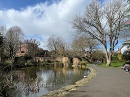
Important trees comprising the woodland of the Queen Elizabeth II Silver Jubilee Gardens
- Along the east bank of the River Severn, stretching between Beales Corner and Millside Court/Severnside Mill, and continuing along the riverbanks beyond the Conservation Area boundary.
- In the Queen Elizabeth II Silver Jubilee Gardens and the woodland adjoining its southern corner.
- In the Lychgate Gardens off Westbourne Street.
- Trees between Pleasant Harbour and the eastern end of the central bridge.
- Within the majority of domestic gardens, except for those properties located along Load Street.
- On the surrounding hillsides and ridgelines—particularly east of Northwood Lane and around The Summer House; to the rear of High Street; around Tickenhill (including its extensive holly boundary hedge); Kateshill and Winterdyne; Maypole Piece; and in private gardens on Venus Bank.
- Along Redhill and Kateshill, where the canopy almost completely encloses the roadway, creating a distinctive tunnel-like effect in summer.
- Following the watercourses south of Tickenhill. This area has been identified by the Worcestershire Wildlife Trust (and in the District Local Plan) as a Special Wildlife Site.
Smaller clusters of trees and shrubs are often glimpsed from the streets, visible through alleys, archways, and above boundary walls. Whether in small groups or larger stands, their presence is vital in softening the edges of the built form and in enriching the visual character of the Area.
The extensive hillside grounds are largely planted with mature, dense groups of native deciduous species. These provide substantial cover to the slopes, while still allowing important outward views from the houses to remain open. Interspersed within these native plantings are occasional specimen conifers. In winter, these conifers stand out strongly against the bare branches of deciduous trees, adding colour and structure to the views. In summer, the native trees dominate the scene, yet without wholly concealing the conifers.
A number of the most significant trees within the Area are protected by Tree Preservation Orders.
A small group of three non-native deciduous trees has been planted on the quayside in front of No. 3 Severnside South. Their presence appears out of keeping in this historically open setting. Ideally, these trees should be removed to restore the area’s historic character, to maintain clear views of the adjoining buildings from the central bridge and Beales Corner, and to avoid the potential for future root-related damage to the quayside structure.
In recent years, there has been a noticeable loss of traditional riverside willow trees along the east bank adjoining the Millside Court and Severnside Mill housing development. The replanting and retention of willow trees in this location would be desirable, both to help stabilise the riverbank and to provide seasonal screening of the Severnside Mill development, which is of a relatively inconspicuous and less sympathetic design.
By contrast, the area of open embankment in front of Beales Corner remains largely free of trees. This open character should be preserved, as introducing new tree planting here would obscure important views of the Beales Corner buildings when seen from the central bridge and the opposite bank of the River Severn.
4.7 Historic Street Pattern and Movement
Town Plan and Street Pattern
The overall plan of Bewdley is defined by two distinct parts lying on either side of the River Severn and its central bridge, with the historic parish of Bewdley on the north-west bank and Wribbenhall on the south-east bank.
The basic plan of the town centre (on the western bank) is broadly rectangular, its long axis aligned parallel with the river. Within this framework, Severnside South forms the lower riverside route and High Street the higher route above, the two being connected at either end by Load Street to the northwest and Lax Lane to the southeast. Immediately north of this rectangle lies a triangular extension comprising Severnside North, which turns west along Dog Lane to reconnect with the western end of Load Street.
From the north-west and south-west corners of the town’s core, a number of roads radiate outward: Dowles Road, Welch Gate, Winbrook, Wyre Hill, Park Lane, and Richmond Road from the north-west, and Lower Park from the south-west, following sinuous routes into the surrounding countryside. To the north-east, the river bridge connects Load Street to a short network of streets and alleys forming Wribbenhall on the opposite bank, which converge towards Kidderminster Road (east) and Stourport Road (south-east).
The Bridge and Early Development
The first bridge across the Severn was constructed in 1447, rebuilt in timber in 1460, and in stone in 1483. The latter collapsed in 1795 and was replaced by the current bridge, designed by Thomas Telford and completed in 1801. Notably, Telford’s bridge was aligned with the north-east end of Load Street rather than the slightly more southerly prominence on Severnside South, where the bandstand now stands.
It is suggested that the earliest route to the river from the west followed the valley of the Winbrook, with Wyre Hill (formerly High Street) developing as a focus of settlement in the 15th century as the town grew. Wyre Hill and Lax Lane likely formed the principal axes of early habitation prior to the construction of the first bridge. Documentary evidence from 1472 refers to Dog Lane, High Street (now Wyre Hill), Over Street (now High Street), and Lax Lane, along with Bridge Gate, Welch Gate, and Dog Lane Gate (possibly the medieval Welsh Pool Gate). Tinkers Gate or Lax Gate likely also dates from this period.
The formation of the town’s street system, therefore, occurred largely in the mid-15th century, linked to Bewdley’s rapid development and a shift of focus from the earlier ford and Lax Lane towards the new bridge and riverside quays. Severnside and Load Street likely originated at this time, although they are not recorded in documents until the 1530s.
 Central Bridge, designed by Thomas Telford
Medieval and Post-Medieval Development
Medieval Bewdley was enclosed by four gates, Welch Gate, Bridge Gate, Tinkers (or Lax) Gate, and Dog Lane Gate, all substantial timber structures with rooms above. The remains of Dog Lane Gate were uncovered in 1959, though no above-ground remains of any survive today. The curved alignment of Dog Lane may indicate the line of a former town ditch. Richmond Road and Dowles Road are also likely to be of medieval origin.
The route from Bewdley to Ribbesford (now Red Hill) currently passes through land once forming part of the royal park attached to Tickenhill Palace. It is improbable that a public highway would originally have traversed a royal park, suggesting that the medieval route may instead have skirted the park’s boundary along the edge of the Severn’s floodplain.
The street pattern in the post-medieval period represents a natural extension of this medieval framework. Park Lane is first recorded in 1595, though it may be earlier. A market range including the barley market, shambles, and butter cross once stood in the centre of Load Street but was demolished in 1783. Wyre Hill remained the principal western route until 1753, when a turnpike road to Cleobury Mortimer was established along the Winbrook valley. The road south from Bewdley, passing the lodge to Winterdyne, likely postdates the break-up of Tickenhill’s medieval park in the late 17th century.
On the east bank, the Kidderminster Road through Wribbenhall probably originated as an old packhorse route between Bewdley and Kidderminster, while the Stourport Road was constructed in 1820.
Historic Footpaths and Routes
Several historic footpaths within the Conservation Area remain important features of its townscape and setting. Some continue to provide access to residential properties, while others link the town with surrounding countryside. These include:
- Park Alley, linking High Street with open countryside.
- The Racks, running parallel to the north side of Winbrook and Cleobury Road.
- The Gob, connecting the lower end of Sandy Bank and Winbrook.
- Venus Bank.
- The path running parallel to the south-west side of High Street, linking Park Lane with Park Alley.
- The path skirting the east and south sides of Tickenhill’s current grounds.
- The track linking the south-west end of Lower Park with Kateshill and the open countryside beyond.
- Three paths leading from High Street, Severnside South and Lax Lane into and out of the Silver Jubilee Gardens.
- The riverside walks along Severnside North, Severnside South, and the east bank—linking the town centre with the countryside and incorporating two regional long-distance trails: the Worcestershire Way (west bank) and the Severn Way (east bank). Preserving the character, setting, and views along these routes is particularly important.
- Pewterer’s Alley in Wribbenhall.
- The footpath encircling the northern edge of Winterdyne Park.
With the exception of Load Street, most roads and footpaths within the Area are relatively narrow. Road junctions typically take the form of “T” or “Y” intersections, and there are no roundabouts, either historically or at present. In several locations, the footpaths are slightly raised above the adjoining carriageway, such as at the western end of Wyre Hill, the eastern end of Sandy Bank, along the south side of Welch Gate, and in front of Nos. 72–78 Kidderminster Road.
It is particularly important to preserve the historic street pattern within and adjoining the Conservation Area — including the routes, widths, gradients, junction arrangements and traditional footpath characteristics — all of which form a key part of the Area’s special architectural and historic interest.
- Vehicular Movement
There is a continuous flow of vehicular traffic using the central bridge and, consequently, the streets leading to it. The historic layout of Load Street provides sufficient width to accommodate on-street parking on both sides, while still permitting two-way traffic and a stacking lane for vehicles entering the short-stay car park.
At the upper end of Load Street, the carriageway divides to pass around St Anne’s Church. Immediately beyond the church, Load Street meets High Street, Park Lane and Dowles Road in close succession before rising further into Welch Gate. The convergence of these multiple routes creates the point of greatest vehicular congestion within the town centre. This is compounded by the merging of through and local traffic flows towards the bridge and by the proximity of the Dowles Road junction, which serves as the principal access to the main car parks.
On the east side of the river, Kidderminster Road carries the heaviest traffic volumes, with its sharply turning junction with Stourport Road being an occasional congestion point. - Pedestrian Movement
Load Street forms the retail and commercial heart of the town, and many local residents access its facilities on foot via High Street, Park Lane, Welch Gate and Kidderminster Road.
Tourist activity is largely concentrated along the riverfront—particularly Severnside North, Severnside South, Beales Corner, the bridge, and Load Street—while Lax Lane, High Street and Welch Gate also attract frequent pedestrian use. The bridge itself, where heavy vehicular flows converge with pedestrian movements from both tourists and residents, can become a point of hazardous conflict.
There are also substantial pedestrian flows between the public car parks (to the rear of Load Street and off Dog Lane) and the town centre and riverside areas. - Public Realm Elements
Recent enhancements have included the installation of modern but traditionally styled black-painted metal railings along the riverfronts at Severnside North, Severnside South (part), and Beales Corner. Similarly, traditionally designed metal litter bins have been installed at various locations throughout the Area, including Load Street.
4.8 Night Time Character and Appearance
During the evening and at night, Bewdley retains a lively and attractive atmosphere, enhanced by the interplay of street lighting, the subtle illumination of individual frontages, and the activity generated by numerous small bars and restaurants. This creates a pleasant environment for sightseeing and leisurely evening walks by both residents and visitors, particularly during the summer months.
However, many existing streetlights are of designs and materials that are unsympathetic to the character of the Conservation Area, and most emit a yellow-toned light that produces an artificial glow inconsistent with the historic setting. Wherever street lighting is installed or replaced, it should emit a soft white light that is more sympathetic to the town’s period character. Fittings should be of a design appropriate to the historic setting, preferably black-painted metal lamp posts in a traditional nineteenth-century style. In some key locations, the reintroduction of gas-style lighting could be considered, provided modern safety and efficiency standards are met.
- Town Centre and Riverfront
The town centre and riverside areas experience the highest levels of evening activity. Although Bewdley has no cinema or nightclub to act as a single focal point, the evening economy naturally centres around Load Street, Severnside North, and Severnside South. Together, these areas form a broad focal zone, drawn by the riverside walks and the concentration of public houses, restaurants, and cafés, particularly along Load Street, High Street, and Welch Gate.
Street lighting along Load Street is provided mainly by lamps fixed close to building frontages. These are regularly spaced and produce a modest, even spread of illumination across the pavements. The lighting of individual buildings is generally restrained, with most frontages subtly rather than conspicuously lit. The church tower is gently illuminated, providing a quiet landmark feature.
Along Severnside North and South, traditional-style free-standing lamps contribute to an attractive and distinctive waterfront character, particularly when viewed from the bridge or from Beales Corner. In contrast, the street lighting within Load Street itself is largely modern and unsympathetic in appearance. A number of removable metal poles have also been installed in the pavements to support seasonal flower baskets and Christmas illuminations; while functional, these are not of a design that complements the historic character of the area. - Wribbenhall
Beales Corner is more modestly illuminated than the town centre, with street lamps creating small pools of light that produce attractive reflections on the river when viewed from Severnside South. This softer lighting contributes to the area’s charm and reinforces its visual relationship with the river.
However, the adjoining petrol filling station on Kidderminster Road is brashly and intensely illuminated. The brightness of its forecourt lighting overwhelms nearby features and detracts from the otherwise subdued and historic character of the surrounding street scene. Measures to reduce glare and improve visual containment of lighting at this site would significantly enhance the appearance of the area at night. - Maypole Piece
Maypole Piece, which remains largely undeveloped and without street lighting, becomes almost completely dark after nightfall. The absence of illumination helps maintain its rural and undeveloped character and contributes to the contrast between the town’s lit urban core and its darker, more natural edges. - Red Hill
Along Red Hill, free-standing lamp standards are set among mature tree canopies, with the foliage concealing the light fittings and creating regular pools of light along the pavement. In other areas, where the lamps are more exposed and irregularly positioned on either side of the road, the lighting appears less consistent. Overall, the partially screened lighting along Red Hill complements its verdant, enclosed character and provides an attractive visual effect, particularly in the summer months.
4.9 Views
- Views into the Area
The surrounding topography of Bewdley, with its undulating hills and wooded slopes, generally limits opportunities for distant views into the Conservation Area. Nevertheless, a number of important vantage points exist — most notably from Trimpley Lane to the south; from the hillsides north of the town, including Northwood and Hill Farm; and from the elevated ground at Blackstone looking northwards.
From these positions, the higher parts of the historic core can be seen, along with the sides of the river valley, the central bridge, and parts of the modern suburbs on the west bank. The wider landscape setting, including the Wyre Forest to the northwest, provides a picturesque and contextually rich backdrop to the town. - Views out of the Area
Due to the same topographical enclosure that limits views into the town, long-distance views out of the Conservation Area are also relatively restricted. The most significant outward views are from the central bridge, looking both upstream and downstream along the River Severn. These views take in tree-lined riverbanks and distant wooded hillsides interspersed with open fields and hedgerows, extending several kilometres beyond the Conservation Area boundary.
The character and integrity of these distant views are an essential component of the town’s historic setting and should be carefully preserved.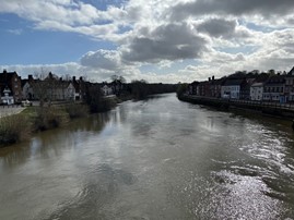
 Distant views from the central bridge looking south (left) and north (right)
Other views outward are generally limited to the middle distance, constrained by the surrounding hills that frame the town centre. These views typically comprise wooded hillsides, some crowned with substantial period dwellings or more modern residential development—most noticeably on the upper slopes of Venus Bank. The wooded character of both the middle- and long-distance views reinforces Bewdley’s identity as a small town set within a predominantly rural landscape. Views to open countryside form an essential part of the Area’s character, helping to preserve the impression of a compact settlement nestled within its natural surroundings. - Views within the Area:
Almost every street and turning within the town offers a notable view—whether of the riverside, groups of buildings rising along sloping streets, or individual structures of architectural and historic interest. The Severn Valley Railway’s steam-hauled trains also contribute to the town’s visual appeal, providing both a distinctive element in outward views and a unique vantage point from which to appreciate Bewdley’s riverside setting.
The most significant views include the following:- From the central bridge, there are wide and striking vistas encompassing the building frontages along Severnside North and South, Beale’s Corner, and the southern end of Kidderminster Road. Views also extend into Load Street and towards the surrounding hillsides, providing a strong visual connection between the town’s historic core, the river, and its wider landscape setting.
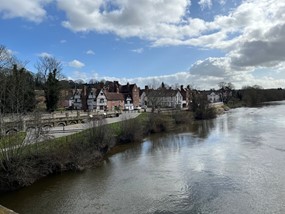
 Severnside North (left) and Severnside South (right) from the central bridge
 - From the quay and river sides on either bank looking directly across the river towards the fronts of buildings and landscape features on the opposite banks, and towards the central
- From High Street looking north east into and across the Queen Elizabeth II Gardens.
- Within the Queen Elizabeth Gardens looking along the footpaths and outwards towards the backs of surrounding buildings and the tower of St. Anne’s Church in Load Street.
- From Bark Hill (off Winbrook) Venus Bank/Church View and the eastern end of the Racks, looking east and south east over the roofscape of the town.
- From the central bridge, there are wide and striking vistas encompassing the building frontages along Severnside North and South, Beale’s Corner, and the southern end of Kidderminster Road. Views also extend into Load Street and towards the surrounding hillsides, providing a strong visual connection between the town’s historic core, the river, and its wider landscape setting.
The most significant views within the area include:
-
- The vistas along the narrow, enclosed frontages visible from both ends of High Street and Lower Park.
- Along the intimate and tightly enclosed pedestrian route of Parkes Passage, off High Street.
- From various points within the town towards the Severn Valley Railway and its steam-hauled trains.
- From the valley south of Tickenhill looking northwards towards the southern edge of the town.
- From the Severn Valley Railway station and line, looking across adjoining rooftops towards the slopes of Maypole Piece and the hillside crowned by the Summerhouse.
- From the Severn Valley Railway station and line, looking towards the buildings on the south-west side of the river and the rising green landform of Red Hill, Kateshill and Winterdyne.
 Redhill and Kateshill, looking south from the Severn Valley Steam Railway Station
 - From the footpaths surrounding Tickenhill looking southeast across the valley towards Kateshill House, Redhill and Winterdyne and reverse.
 Kateshill House and Redhill, looking southeast from Tickenhill
 - From the footpaths in the fields to the rear of Lower Park looking towards Tickenhill.
- From the footpath at the rear of High Street looking northeast into and over rear elevations and gardens.
- Looking southeast along High Street and Lower Park and southwest from the Gardeners Meadow car park to the sudden backdrop of undeveloped farmland that comprises the hillside of Red Hill at the northwest end of Winterdyne.
4.10 Pattern and Density of Buildings
The pattern and density of buildings and plots within the Conservation Area strongly reflect their medieval origins, as follows:
- The prevailing pattern of development consists of buildings arranged along the length of streets in long, narrow plots set at right angles to the street axis. Many of these may represent surviving burgage plots, the earliest of which were recorded in the fourteenth century.
- Plot boundaries are typically defined by walls.
- In some cases, adjoining plots have been amalgamated; however, such unification is undesirable in character terms as it erodes the historic pattern.
- The principal building on each plot is usually positioned directly on the street frontage and faces the street. These are often accompanied by smaller ancillary buildings or ranges to the rear, historically used for domestic or small-scale industrial purposes. These subservient structures are usually of a reduced scale and extend back at right angles to the street within the narrow plot.
- In many cases, buildings are accessed via side alleys or tunnel archways leading through from the street. This traditional pattern remains evident today, particularly when viewed from behind the main frontages.
- Where buildings occur, there is a strong impression of high-density development. Buildings are generally of individual design or appear in small terraced groups, though they often adjoin to form longer terraces, creating an almost continuous street frontage.
 Terrace of individually constructed houses adjoining the Kidderminster Road in Wribbenhall
 - Set within the tightly knit pattern of development, and occasionally on its periphery, are larger plots historically associated with wealthier families or individuals holding prominent community positions. The houses occupying these sites are notably larger and of superior architectural quality. Notable examples include The Redfern on High Street and the Old Vicarage on Lower Park, both of which date from the Georgian period or incorporate Georgian remodelling of earlier buildings.
 Old Vicarage in Lower Park; a substantial house set in extensive ground
4.11 Style of Buildings
There are three particularly important styles of buildings within the Area, as follows:
- A number of vernacular timber-framed buildings of late medieval to 17th century origin survive within the Area. The larger buildings usually incorporate jetted upper floors, close studding, mid rails and front facing gables. Some include elaborate quatrefoil panels and carved brackets. The smaller and/or less elaborate buildings usually incorporate square framing.
 Variations of timber framing in the conservation area.
 - The predominant architectural style of buildings surviving within the Area is Georgian, characterised by classically inspired façades, symmetrical proportions, and a sense of polite formality. These buildings vary in quality from modest “courts” and workers’ cottages that adopt simplified classical features, to grander houses and public buildings displaying a richness of architectural detailing and ornamentation. Many Georgian façades conceal earlier timber-framed cores, often revealed through contrasting rear elevations or exposed structural timbers in gable ends. Such features make an important contribution to the Area’s historic character and should be preserved wherever they occur.
 Variations of Georgian style with the conservation area.
 - To a lesser extent, there are also nineteenth- and early twentieth-century buildings, ranging from modest cottages to larger houses, expressed in a variety of styles. Some of these structures draw upon the vernacular traditions of timber framing, others reflect the polite formality of the Georgian period, while a number incorporate mixed influences, including Gothic revival detailing. There are also examples of late twentieth-century development, though few display a genuine understanding of, or sympathy with, the earlier architectural character of the town.
It is particularly important that any new development within or adjoining the Conservation Area reflects and harmonises with the established vernacular and Georgian styles characteristic of the locality.
4.12 Size and Morphology of Buildings
Buildings within the Area are predominantly of two or three storeys in height. Load Street is almost entirely composed of buildings of three or four storeys; Severnside North, Dog Lane and Westbourne Street are characterised by two-storey development; Lax Lane contains a number of one- and one-and-a-half-storey cottages (the latter often incorporating later dormer windows); and Welch Gate is mainly of two and two-and-a-half storeys. There is little tradition of single-storey buildings within the Area, other than small rear ranges or those historically associated with specific industrial or service uses.
With the exception of High Street, most streets are of equal or greater width than the height of their adjoining buildings, creating a sense of space and openness. In contrast, Westbourne Street, High Street and parts of Welch Gate are notably narrower, contributing to a more enclosed character.
Building massing within most streets is varied, reflecting differences in storey numbers, individual floor heights and the natural changes in topography. This results in an irregular but generally harmonious roofscape, with varied eaves and ridge lines adding visual interest. In Welch Gate, however, the massing is more consistent, stepping up rhythmically with the rising gradient into Winbrook.
The foregoing characteristics contribute to an overall sense of harmony and compatibility with the human scale, allowing the pedestrian to feel comfortable within the townscape. Only in parts of High Street and Load Street, particularly in the vicinity of St Anne’s Church, does the combination of building massing, height, and alignment begin to overpower the human scale.
Windows and doors are generally arranged with a degree of regularity, creating a strong sense of rhythm that enhances the visual coherence of the street scene and complements the overall alignment of buildings. In Welch Gate and Dog Lane, this rhythm is less apparent, while in Lax Lane, the ground-floor openings form a distinct pattern. In Lower Park and Park Lane, rhythm tends to occur within individual facades rather than extending uniformly along the street.
Georgian buildings of three bays typically exhibit symmetrical facades, while those of two bays are usually symmetrical above the ground floor.
The predominant roof form throughout the Area is with ridges aligned parallel to the street. A number of buildings, particularly in Load Street, have hipped roofs facing the street, while many pre-seventeenth-century structures are arranged with ridges running perpendicular to the road, a characteristic still visible in rear elevations. Timber-framed buildings often feature front-facing gables, reinforcing the vernacular character.
Roof pitches are generally steep or of medium-steep inclination. In Load Street, and among many of the Georgian buildings elsewhere, roofs are partially concealed behind parapets; elsewhere, parapets are largely absent, especially on vernacular or smaller polite buildings.
Dormer windows are a common feature throughout the Area, particularly in Lax Lane and High Street, where they are typically gabled to the street with simple clipped verges and plate-mounted construction. In contrast, Dog Lane and Park Lane are notably free of dormers. Modern rooflights, such as Velux types, are occasionally seen, often as later additions rather than original features, and can appear somewhat incongruous within the historic roofscape.
Chimneys remain a consistent feature across the Area, typically well-proportioned and of sturdy form, contributing significantly to the overall silhouette.
The varied and historic roofscapes are of particular visual interest, especially when viewed from elevated vantage points such as Venus Bank and Church View, from which the complex interplay of roofs, ridges, chimneys, and materials forms one of the most distinctive and picturesque aspects of the town.
4.13 Materials and Construction
- Walls:
The predominant material used in the Area’s timber-framed buildings is oak, originally left unpainted but now often seen with natural light red-brown tones or cream-washed infill panels. The structural timbers are expressed externally and typically comprise studs, braces, wall plates, mid-rails, end rafters (with or without bargeboards), and the lower ends of principal rafters forming modest projecting eaves. Upper floors are frequently jettied, and in some cases, the exposed timbers are moulded. Corners and changes in plane are often articulated with carved wooden brackets, while smaller brackets commonly support the undersides of projecting window ledges. Traditional wooden pegs are generally used to secure the joints, a detail that contributes to the authenticity and craftsmanship evident in these historic structures. Ornate detailing on timber framed buildings
The predominant walling material for post-seventeenth-century buildings is a locally produced, plum-coloured, well-fired brick. These bricks typically display an open texture, with irregular surfaces and arrises that contribute to the richness and depth of the façades. They are traditionally laid in Flemish bond with narrow joints and finished with white lime putty mortar, usually flush to the face. Older or lower-status buildings often employ more irregular English bond, combining stretcher and header courses. The natural variation and surface irregularity of the bricks create a distinctive visual texture across the townscape.
Buildings of higher status are constructed in a more evenly fired soft red brick, often featuring gauged rubbed brick window heads and arches, and decorative details such as painted corner quoins. Subtle darkening of some bricks caused by uneven firing adds further character and patina to the façades. In several cases, brickwork is complemented by plinths, doorsteps, or other features formed in locally quarried red sandstone.
Painting of brickwork, however, detracts from the quality and character of this material and should generally be avoided. Georgian buildings frequently incorporate sandstone or rendered quoins for visual emphasis, while there is no local tradition of decorative brick banding in contrasting colours. The use of deep brown or heavily uniform modern bricks, such as those seen at Eastham Court, Severnside South, is particularly inappropriate within this historic context. Brickwork with a traditional Flemish bond
Free standing brick walls are traditionally capped with semi-circular shaped coping bricks or semi-circular shaped sandstone. Traditional semi-circular coping to the top of a wall
 - Roofs:
The predominant roofing material within the Area is the small, red-brown plain clay tile, typically darker in tone than the accompanying brickwork. These handmade tiles often display slight natural curvature, creating a subtly uneven surface that adds warmth and texture to the roofscape, qualities that are not replicated by modern, machine-made equivalents. While some buildings have been re-roofed in grey slate, this material is generally less sympathetic to the historic character of the area. Pantiles are not traditional to Bewdley and should be avoided in future repairs or development. No examples of thatch survive within the area today.
Buildings dating from the Georgian and Victorian periods predominantly feature simple double-pitched roofs, terminating either in gable ends with flush verges sealed by a mortar fillet or, less commonly, being hipped on all sides. These buildings typically have no front-facing gables or significant eaves overhangs. Where bargeboards occur, they are infrequent but often finely detailed, featuring pierced or cusped ornamentation. In contrast, timber-framed buildings characteristically display bargeboards along their gables, while verged gables are otherwise rare within the area.
Brick dentilling is the most common form of eaves treatment, though parapets, cornices and modillions are also used. Enclosed soffits are not traditional and should be avoided in any new or replacement work. Saw tooth dentilling (top left, hit and miss header detilling (top right), high quality eaves treatment (bottom)
Lead is the traditional material for flashing, cut to step with and into brick mortar courses, rather than the modern trend of setting into disc-cut grooves in the brickwork.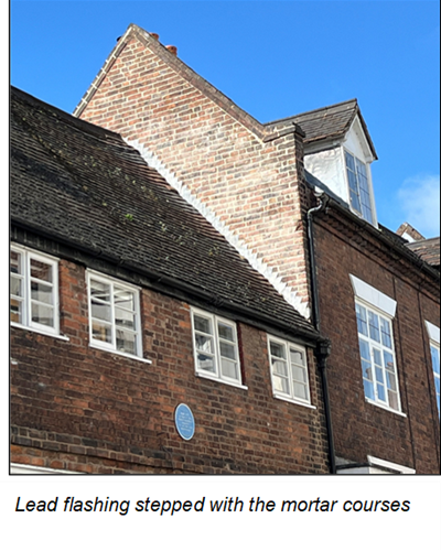
Chimneys are a prominent and characteristic feature throughout the Area. They are typically tall, square or rectangular in plan, and constructed in brick to match the main building fabric. The most common position is ridge-mounted, set at right angles to the ridge in the case of rectangular stacks, although a number are located mid-slope. Chimneys frequently occur at party divisions within terraces or at gable ends, where they are built into the wall thickness rather than applied externally. Most retain modestly detailed cappings, and many still display their original clay pots, which contribute to the historic roofscape. - Doors and Windows:
Door and window openings are generally rectangular in form. Windows to timber-framed buildings are typically horizontally proportioned, whereas those to later brick buildings, particularly the more formal Georgian examples, are vertically proportioned. Timber is the universal material for windows and door joinery, left natural or stained on timber-framed buildings and painted (most commonly white) on later structures. Many doors retain ornate period metal fittings, including handles, letter plates, and knockers. Original window glass is still present in a number of cases and should be preserved wherever possible.
Few original doors to timber-framed buildings survive; those that do are usually of unpainted oak, with substantial iron hinges, strapwork, nails, and fixtures. Later doors are frequently panelled, with higher quality Georgian examples displaying six panels and brass fittings. More modest cottages and working buildings often feature simple boarded doors of vertical planks with cast iron furniture.
With the exception of Severnside North, Dog Lane and Park Lane, many of the better post-medieval and particularly Georgian and Victorian buildings include classically inspired doorcases, typically incorporating side columns, pediments (or bracketed canopies), and box or fanlights. Some terraced properties retain tunnel entrances giving access to rear plots, while certain former courts have communal archways from which front doors open. Many entrances are approached by stone steps and accompanied by cast-iron shoe scrapers set into the ground. A variety of doors/entries in the conservation area, representative of the diverse styles and phases of architecture found in Bewdley.
Window openings in timber-framed buildings are exclusively flat-headed and incorporate both transoms and mullions. These windows would originally have been fitted with shutters rather than glass, later replaced by side-hung casements with small leaded lights, typically arranged in rectangular or diamond-patterned lattices. In some cases, openings have been extended through the mid-rail, likely representing later and less sympathetic alterations. Occasionally, windows are set within projecting frames supported on timber brackets, particularly where positioned directly beneath a jettied upper floor.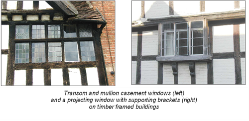
For later buildings, the most common form of window head is flat, although segmental (arched) brick heads are almost as frequent, particularly on more modest buildings. This treatment is especially evident in Welch Gate, Lax Lane and Dog Lane. Flat heads to post-seventeenth-century buildings typically incorporate rubbed and gauged brick voussoirs, sometimes with a projecting central keystone, or applied headers painted white. Voussoirs are always individually gauged, contrasting with the unsympathetic modern practice of using ungauged rectangular bricks with a gauged brick at each end supported on a concealed lintel. Applied headers are often ornamented, commonly with rustication.
Among the finer Georgian buildings, there are notable classically inspired variations in window design, including Venetian windows (a central semi-circular-headed window flanked by two flat-headed openings with arched glazing bars to the central light), thermal windows (semi-circular) to upper floors, and near-square windows with semi-circular heads. In general, the top-storey windows of formal post-seventeenth-century buildings are more nearly square in proportion than those on lower floors, which are vertically elongated.
In these later buildings, windows are either recessed within the reveal and framed with a narrow wooden architrave, or set flush with the wall face with a wider architrave—both arrangements occurring with roughly equal frequency. Cills are of projecting stone or timber, commonly painted white, though higher-status Georgian and Victorian examples tend to have stone cills. By contrast, some late twentieth-century buildings feature unpainted concrete cills, which are unsympathetic to the historic character of the Area.
The better-quality Georgian and Victorian buildings generally retain vertically sliding sash windows, with timber glazing bars dividing the openings into vertically proportioned rectangles. Where side-hung casements occur, they often feature horizontal or both horizontal and vertical glazing bars, dividing the aperture into rectangular panes. A small number of modern or adapted older buildings have casement windows without glazing bars, a treatment that is particularly inappropriate in character terms. Horizontally sliding sash windows also occur occasionally, especially to upper storeys.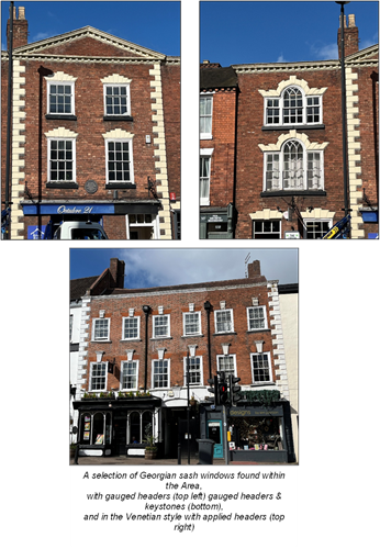
Dormer windows are a frequent feature throughout the Area. They generally have pitched roofs with gabled, rather than hipped, forms and lead-clad sides. The predominant type is plate-mounted, although a small number are off-plate or purlin-mounted. There is no historic tradition of rooflights within the Area; however, a few examples have been inserted into roofs in Wribbenhall, to the detriment of the buildings’ historic character and overall appearance. Plate mounted dormer windows
 - Shopfronts
The Georgian and mid-Victorian examples, with their multiple glazing bars and finely detailed joinery, are the most sympathetic to the historic character of the Area. Later Victorian and Edwardian shopfronts introduced larger panes of plate glass, reflecting changes in retail display practices. A number of former shops, particularly along Welch Gatehave since reverted to residential use but have retained their traditional shopfronts, providing valuable evidence of the Area’s commercial past.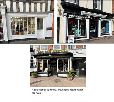
- Watergoods:
Cast iron is the predominant material used for rainwater goods, including gutters, hoppers and downpipes. In Load Street, there are particularly fine and ornate examples, with some hoppers also formed in lead. These traditional materials contribute to the historic character and should be retained or reinstated wherever possible. The use of grey plastic rainwater goods is inappropriate within the Conservation Area.
4.14 Survival of Architectural Features
The Conservation Area has retained a substantial number of original architectural features. This is almost certainly due to the high proportion of listed buildings, where statutory controls have prevented indiscriminate losses. However, many unlisted buildings of interest also survive with original details, although in some cases such features have been altered or lost.
Important surviving architectural features include the following:
- Pitched roofs, plain clay roof tiles and original chimneys.
- Timber sash and side-hung casement windows (often incorporating leaded lights and/or horizontal glazing bars).
- Gauged, applied rusticated, and segmental brick window headers.
- Traditional timber doors, either panelled or boarded, with original metal fixtures and fittings.
- Structural plinths, front door steps, boot scrapers, and other traditional entrance details.
- Exposed timber framing to older buildings, including beneath later façades.
- Unrendered brickwork.
- Traditional plain roofing tiles and natural slates.
- Undeveloped rear gardens.
- Plot-dividing walls and historic outbuildings.
- Traditional shop fronts, particularly in Load Street and the lower end of Welch Gate.
- Traditional railings to the fronts of dwellings, especially in High Street.
- Small archways and tunnel entrances leading to rear spaces.
- The historic pattern and form of highways.
- Old metal street signs and cast-iron court number plates on doors.
Notable losses or damage to architectural features include:
- Repointing with cement-based (often coloured) mortars instead of lime putty mortar, and the use of inappropriate pointing techniques.
- Replacement of cast iron rainwater goods with PVCu alternatives.
- Application of modern stains or inappropriate paint colours to timber joinery.
- Replacement of original timber doors with unsuitable modern alternatives.
- Painting of historic brickwork.
- Replacement of timber framing, particularly to ground floors, with modern brickwork.
- Installation of inappropriate shop canopies and unsympathetic frontage treatments.
- Use of inappropriate street furniture, highway surfacing, lighting columns and highway signage.
Although these unsympathetic alterations have not yet caused widespread harm to the architectural and historic interest of the Area, it is important that remedial and preventative measures continue to be taken where necessary to preserve its special character.
4.15 Wyre Hill
Wyre Hill is almost a hamlet in its own right and is perhaps the oldest part of the town. It has an overwhelmingly vernacular character, defined by humble cottages of timber-framed construction, some of late medieval origin, and later brick-built cottages. The area is approached from the town centre via Welch Gate and Sandy Bank, the latter rising steeply across the contours for about half a kilometre, bordered on the south side by important undeveloped wooded banks. Wyre Hill begins just before the hillside crests onto a plateau high above the town.
The road is narrow and winding, lacking pavements in its lower reaches. A few houses sit tight against the road on the Winbrook valley side, while opposite lies a steep, wooded bank. As the upper settlement begins, pavements reappear, rising to levels high above the road. In these sections, road and pavements are separated horizontally by grassed banks, creating generous space between building frontages and the carriageway. This open character gives Wyre Hill a comfortable, human scale and distinctive spatial quality. Gaps between short terraces of cottages allow gardens to reach the pavement edge and contribute to the street’s charm; these open breaks are important to preserve free from infill development.
The historic settlement forms a linear ribbon approximately 300 metres in length. The Conservation Area boundary coincides with the extent of the historic core, beyond which the settlement continues with incongruous modern residential development on three sides.
Buildings are uniformly two storeys in height and date predominantly from the 18th and 19th centuries. They are positioned at the back of the pavement and orientated towards the street. The presence of earlier timber-framed cottages amongst later brick structures indicates the early foundation of the settlement. Window and door openings generally have a vertical emphasis, though the rhythm along the street is irregular due to the steep contours. This creates a picturesque stepping effect in eaves and ridgelines, exposing gable profiles and enhancing the area’s visual interest.
The principal walling material is a dark reddish-orange brick, though some cottages have been painted white, an unsympathetic later alteration. Roofs are mostly of reddish-brown plain clay tiles, with a few in natural grey slate. Brick dentil detailing is common at the eaves, and ridge-mounted chimneys typically crown the gabled ends. Window and door openings are more often cambered than flat-headed, with white-painted timber frames set flush with the wall face. Architectural features generally survive well, though the introduction of uPVC rainwater goods represents a noticeable intrusion.
Wyre Hill demonstrates a similar pattern of historic growth to the town centre, evolving from medieval to Georgian and Victorian periods. It shares a close relationship with Welch Gate, particularly in the way the road and pavements have been formed in response to the steep topography.
4.16 Landmarks, Focal Points and Special Features
There are numerous landmarks, focal points and special features within and adjoining the Conservation Area that are of particular importance in conservation terms. These features contribute significantly to Bewdley’s visual identity, legibility, and sense of place.
- Landmarks
Landmarks are buildings, structures or natural features whose size, design, or position makes them particularly prominent or distinctive within the townscape. They act as visual reference points and play a key role in defining the character and spatial experience of the area. Special care is therefore required in their management and any proposals affecting their setting.
The River Severn itself, together with the surrounding elevated ground, form the most significant natural landmarks within and adjoining the Conservation Area. In addition to these, a number of man-made landmarks contribute to Bewdley’s distinctive character, including:- The full lengths of the Severnside frontages, the central bridge, quaysides, and buildings at Beale's Corner, all of which have collective value as landmarks.
- Anne's Church in Load Street.
- Hill top buildings and their settings, including Tickenhill, Kateshill House, The Summer House and Winterdyne (outside Area).
Particularly important buildings in larger groups, including as follows:- Load Street: Town Hall, Nos. 14, 15 (HSBC) and 17, George Hotel, 70 & 71.
- High Street: No. 11 (Redfern) and 62 (Manor House).
- Lower Park: No. 1 (The Rectory) and 15 (Lower Park House).
- Severn Valley Steam Railway viaduct over Kidderminster Road and Black Boy Hotel.
- All Saints Church (Wribbenhall) outside the Area but comprising an important gateway
- Focal Points:
Focal points are buildings, structures or areas, that are important because of their position in view lines; or because they are the centre of well frequented public activity. Special care is needed in the treatment of focal points because they are particularly noticeable to the public.
It is difficult to isolate individual sites or buildings within an area so rich in interest and appeal but they include the following:
Landmarks are buildings, structures, or natural features that, by virtue of their size, design, or position, are particularly prominent within the townscape. They serve as visual reference points and contribute to the distinct identity and legibility of the Conservation Area. The River Severn itself, together with the surrounding elevated ground, forms the principal natural landmark. Several man-made landmarks are also of considerable importance, including:
- The full lengths of Load Street and the Severnside frontages, the bridge, and Beale’s Corner – collectively forming the town’s most prominent visual ensemble and acting as a principal focal point within views both along and across the river.
- Queen Elizabeth II Gardens and the adjoining public car parks behind Load Street and Lax Lane, which provide open breaks within the dense urban grain and afford important public views of the townscape.
- Individual landmark buildings, including:
-
- St Anne’s Church and No. 15 (HSBC), Load Street – a dominant architectural pairing at the heart of the town.
- Town Hall and Museum, Load Street – a civic focal point of strong historical and architectural presence.
- Nos. 42 and 62 (Manor House), High Street – fine examples of substantial Georgian houses.
- Nos. 7 and 8, Lower Park – notable for their scale and historic character within the riverside setting.
- The Railway Viaduct over Kidderminster Road – an impressive engineering structure of historic and visual significance.
- Nos. 34 and 35, Kidderminster Road – prominent Wribbenhall buildings forming a distinctive entrance to the town from the east.
- Outdoor market to the rear of Load Street, which becomes a focal point by virtue of associated public activity on market days.
 Load street seen from the central bridge with the landmarks and focal points of HSBC (left of centre) and St Anne's church (centre)
Many other smaller buildings act as focal points where they terminate, line or close view lines, particularly looking along roads, pathways and in the vicinity of highways junctions.
- Special Features:
The Conservation Area contains 267 statutory list entries, relating to approximately 550 listed buildings and structures, together with several other buildings of local architectural or historic interest, primarily dating from the eighteenth to early twentieth centuries. While some of these later buildings have experienced unsympathetic alterations, such as window replacements or the application of render, none are beyond sympathetic repair or reinstatement, which should always be favoured over redevelopment.
In general, the retention and careful repair of all historic built fabric, particularly that dating from the medieval period through to the early twentieth century, should be regarded as a key conservation priority.
Particularly special features include the following:
- The bridge, together with its associated balustrades, quaysides, and river edgings.
- The range and variety of period architectural detailing and traditional construction techniques representing different historic phases of the town’s development.
- The historic street pattern of roads, footpaths, and alleyways, including those providing pedestrian-only access and the narrow roadways flanking St Anne’s Church.
- The distinctive town plan, which narrows or “pinches” towards the river, forming a unique spatial relationship with the waterfront.
- The authentic roofscape, characterised by varied pitches, materials, and historic chimney forms.
- Traditional railings to the fore of many properties (for example, at No. 62 High Street).
- Extensive views to surrounding hillsides and open countryside, providing a vital landscape setting.
- Open spaces within and adjoining the Area, and the close proximity of open countryside, notably along the river frontages, and to the south of High Street, Lower Park, Winterdyne, and Tickenhill; as well as across Maypole Piece and along Northwood Lane.
- Numerous trees and hedgerows, including the holly hedge enclosing Tickenhill and the woodland adjoining the south-east corner of the Jubilee Gardens.
Importantly, at least ten medieval buildings survive within the modern town. These include 15th-century timber-framed houses and possibly a market building on Wyre Hill; 15th-century timber-framed houses on Winbrook, Welch Gate, High Street, and Lax Lane; and a 14th-century timber-framed hall with cross-wing on Stourport Road. It is also likely that further medieval structures survive concealed behind later facades.
Notably, four 15th-century framed bays belonging to the medieval palace survive within the 18th-century Tickenhill Manor. In Wribbenhall, a partially reconstructed medieval cross stands on the site of the chapel built in 1719.
In addition, there are numerous buildings dating from the 19th and early 20th centuries that are of architectural and historic interest, contributing to the depth and continuity of Bewdley’s built heritage.
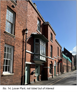
4.17 Open Space
Open spaces are areas with little or no built development. They include public or private gardens, undeveloped hillsides, expanses of water, and street squares. The Conservation Area contains numerous open spaces, both large and small, which reveal themselves through archways, over boundary walls, along rising slopes, and between buildings.
These spaces provide visual breaks and contrast to the geometric form of the built environment. Many contain trees that add further visual interest and opportunities for shade, enclosure, and seating from which various views of the Area can be enjoyed. Open spaces often form an important part of the Conservation Area’s setting, particularly where they abut its boundaries or feature prominently within key view lines and vistas.
The principal areas of open space include the following:
- Queen Elizabeth II Silver Jubilee Gardens, together with the woodland adjoining its south-east corner.
- River bank adjoining Severnside South (north-west end), the central bridge area (including the bandstand), and Gardeners Meadow car park, the first and last of which extend beyond the current Conservation Area boundary.
- Cricket pitch and adjoining riverside meadows to the south-east of Gardeners Meadow car park, extending beyond the existing boundary.
- Red Hill and Winterdyne parkland to the south-east, within and extending beyond the Conservation Area.
- Kates Hill and parkland, within and extending beyond the Conservation Area.
- Tickenhill, including land to the south-west, south and south-east, within and extending beyond the Conservation Area.
- Hillsides adjoining Winbrook and Cleobury Road, within and extending beyond the Conservation Area.
- Land adjoining Gibraltar House (Dowles Road).
- Riverside meadows extending north-west from Severnside North (north-west bank of the river), beyond the existing boundary.
- Boundary along the western side of Dog Lane car park.
- Riverside meadows and bowling green off Riverside North (north-east bank of the river), extending beyond the Conservation Area boundary.
- Hillside and summit in the vicinity of the Summer House and Gloucester Way, Wribbenhall.
- Lychgate Gardens, off Westbourne Street and Stourport Road, Wribbenhall.
- Maypole Piece, Wribbenhall, including the hill, hillside, and the undeveloped gap between All Saints Church and the petrol filling station.
- River bank at Beales Corner, and the stretch from Millside Court through to Bewdley High School on the north-east side of the River, both within and extending beyond the existing Conservation Area boundary.
- Wooded area adjoining the north-east side of the central bridge land arches at Beales Corner.
- Numerous private gardens and undeveloped plots (not all identified on the map), including the extensive garden surrounding the Rectory in Lower Park.
It is particularly important that these spaces are retained free from built development or intrusive structures, as they contribute significantly to the Area’s character, setting, and sense of openness.
It would be desirable to investigate opportunities for public access and the creation of a viewing point at the top of Maypole Piece, from which the town, river, and surrounding landscape could be appreciated.
4.18 Ground Surfaces
There are four principal types of surface treatment across the Area, each having a distinct impact on its visual quality and historic character:
- Modern tarmac is by far the most common surfacing material for both roads and pavements. While practical, it is historically and visually inappropriate within the Conservation Area. Its uniform appearance, ranging from weak to medium grey depending on whether it is dry or wet, offers little visual texture or relief, and detracts from the historic character of adjoining buildings and spaces.
- A short stretch of old moulded blue clay setts laid in a criss-cross pattern survives along the eastern end of The Racks (parallel to Winbrook). Limited areas of historic cut stone setts or cobbles also remain in front of both the Town Hall and Phipps and Pritchard (Load Street), and within the wagon entrance to 21 Load Street. Small patches of uncut pebbles or cobbles survive in parts of High Street and before Nos. 1–9 Kidderminster Road (off the vehicular highway).
Traditional-style paving materials, such as square grey slabs, have been introduced throughout Load Street. However, their regularity of size and uniform texture lacks the subtle irregularities that give genuine historic paving its character. In Severnside North, semi-traditional road setts (Marshall Tegula) and riven stone paving slabs were installed by the County Council during the 1990s. Occasionally, kerbs are defined in traditional stone, though most are formed from modern pre-cast concrete, which is visually intrusive. In parts of High Street, the erosion of modern tarmac has revealed older stone-edged gutters, providing a glimpse of the street’s earlier construction and surface treatments.
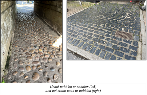
- Some properties incorporate traditional style metal railings to their fore, whilst in other cases traditional style railings enclose or delineate other spaces and features.
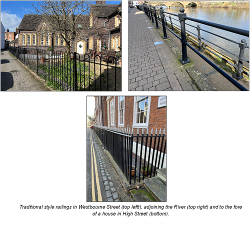
- Grass is present both in small private gardens and in larger communal open spaces throughout the Area. In smaller patches, it contributes texture, colour, and visual relief, softening the hard edges of buildings and paving. In larger expanses, grass plays a more significant role by tempering the dominance of built and hard-surfaced elements within the townscape. It achieves this in two key ways: firstly, through the natural irregularity of growth and mowing, which introduces a sense of softness and informality; and secondly, by following the land’s natural contours and varied shapes, helping to contrast with surrounding buildings and streets while reinforcing a comfortable human scale and spatial balance within the landscape.
- Water is present most prominently in the broad expanse of the River Severn, which forms a defining feature of the town’s setting, and in the ornamental pool within the Jubilee Gardens. Together, these elements add significant visual interest and variety to the Area, their changing colours, surface movement, and reflections enhancing both atmosphere and aesthetic appeal. Water also acts as a natural focal point, drawing the eye and reinforcing the Area’s relationship with its landscape context.
Any proposed development situated where it may be reflected in the river or other water surfaces should be carefully considered, with conscious attention to how its mirrored image might either enhance or detract from the overall townscape character.
4.19 Tranquil and Active Areas
The Conservation Area contains both tranquil and active areas, each contributing in different ways to its overall character and sense of place.
Tranquillity refers to the peace of a place where the sights, sounds, and smells of human or mechanical activity are minimal or absent. Such areas are increasingly rare within town centres and are particularly valuable for providing contrast and respite from busier spaces. It is therefore important to retain their quiet, reflective character.
Tranquil areas include:
- The Queen Elizabeth II Silver Jubilee Gardens and the network of backland plots behind Load Street, Severnside South, Lax Lane, High Street, and Lower Park.
- The network of backland plots, footpaths, and open land to the south-west of High Street and Lower Park, and to the south of Tickenhill, including:
- Park Alley and the footpaths leading up from there to Tickenhill and open countryside.
- The footpath on the south-eastern slopes of Tickenhill.
- The footpath leading west from the bottom of Red Hill.
- Lychgate Gardens in Wribbenhall.
- Parts of the footpath running parallel to the north side of Winbrook and Cleobury Road.
In these areas it is possible to become detached very quickly from the noise, movement, and general activity of the town centre, and to appreciate the more natural and reflective qualities of the Area.
Active areas are those characterised by a high level of movement and interaction, or where focal points attract people for social, commercial, or recreational purposes.
The most active areas include:
- The main roads and pavements where there is frequent vehicular and pedestrian movement — including Kidderminster Road, the River Bridge, Load Street, Severnside South, Welch Gate, Winbrook, and the car parks off Dog Lane. In these locations, traffic noise and emissions are noticeable environmental detractors.
In Welch Gate, Winbrook, High Street, and on either side of St Anne’s Church in Load Street, the narrow pavements can cause conflict between vehicles and pedestrians. While the restricted carriageway widths contribute positively to the historic character, they present modern challenges for accessibility and pedestrian safety. - The open-air market between Dog Lane and Load Street, which generates regular activity and contributes to the vitality and social character of the town centre.
- The Silver Jubilee Gardens, which, although accessible only on foot and free of vehicular traffic and ball games, remain highly popular with both residents and visitors. This space therefore combines qualities of both tranquillity and activity, particularly during the tourist season.
4.20 Noise
There are several types and sources of noise within the Conservation Area, some of which detract from its character, while others contribute positively to its distinctive sense of place.
Detracting noises include:
- Motor vehicle traffic, which is the most significant source of intrusive noise. The impact is greatest along Kidderminster Road, Beale’s Corner, the central bridge, Load Street, Welch Gate, Winbrook, and around the Dog Lane car parks. Although traffic noise is an environmental detractor, it is an inevitable consequence of the town’s road network and its function as a local centre, where through-traffic cannot be entirely avoided.
- Late-night music emanating from some of the public houses within the Area. Noise occasionally intrudes into nearby residential areas, particularly in High Street, associated with the Talbot and Little Packhorse public houses.
More acceptable and characteristic sounds contribute positively to the Area’s atmosphere and reinforce its historic and natural setting. These include:
- Birdsong in the outer parts of the Area, particularly within the Silver Jubilee Gardens, adjoining woodlands, and private rear gardens.
- The calls of geese, swans, ducks, and gulls along and over the River Severn.
- Human voices from casual conversation on the streets and riverside walks, contributing to a sense of vibrancy and community.
- Church bells, which mark the passage of time and maintain a traditional aural link with the town’s historic identity.
- The whistles and sounds of steam trains arriving and departing from the Severn Valley Steam Railway station in Wribbenhall, which form a distinctive and evocative feature of the local soundscape.
4.21 Smells
Certain odours within the Conservation Area detract from its character and amenity. These include the following:
- Vehicular fumes, particularly along Kidderminster Road, Beale’s Corner, the central bridge, Load Street, Welch Gate, Winbrook, and around the Dog Lane car parks. In these locations, emissions from traffic are a notable environmental detractor, diminishing air quality and the overall experience of the public realm.
- Cooking odours from restaurants and takeaway premises in Load Street and Welch Gate. Extraction equipment, including external ducting and fans, often installed on rear elevations, can be visually intrusive. Such installations are frequently finished in bright metallic colours that contrast harshly with traditional materials and tones. Where possible, ductwork should be discreetly located and finished in a subdued, recessive colour (such as dark red or black) to reduce visual impact and better integrate with the surrounding built fabric.
4.22 Alien Features
Alien features are elements that were introduced after the Area’s prevailing historic architectural character had been established, and which do not reflect its traditional forms, materials, detailing or methods of construction. The following features are considered to detract from, or sit uncomfortably within, the established character and appearance of the Conservation Area:
- Lampposts, pedestrian crossing lights, bus shelters and railings of unsympathetic style and finish.
- Excessive or poorly designed traffic signage and street clutter detract from the character and visual coherence of the Conservation Area. This includes oversized or unnecessary signage, such as the yellow parking directional signs at either end of the central bridge, which disrupt key views and the historic setting.
- The use of tarmacadam for pavements and road surfacing within sensitive historic locations, together with prominent yellow road markings, erodes the traditional appearance of the streetscape. More recessive surfacing treatments and lighter-toned line markings would better preserve the character and appearance of the Area.
- Overhead telephone wires and associated infrastructure interrupt important views and detract from the historic roofscape, notably in Lax Lane and Welch Gate. The presence of a modern metal telegraph pole in Westbourne Street is similarly visually intrusive within the street scene.
- Modern telecommunications kiosks and other standardised street furniture that do not reflect local character, such as the telephone box adjoining the Load Street car park, detract from the Area’s historic quality.
- The installation of satellite dishes on prominent elevations or roof slopes visible from the public realm harms the visual integrity of buildings and the wider townscape.
- Unsympathetic modern materials and architectural products diminish architectural authenticity and detailing. These include uPVC windows and doors, standard off-the-shelf replacement doors, concrete window cills and lintels, proprietary roof lights set flush within historic roof slopes, and repointing in hard cement mortar rather than breathable lime mortar.
- Inappropriate shopfronts, fascias and display windows that fail to respect historic proportions, materials or detailing, particularly along Load Street, disrupt the architectural rhythm and coherence of the commercial frontage.
- Fixtures, signage, lighting and other fittings bolted or screwed directly into historic brickwork or masonry cause lasting damage to building fabric and should be avoided.
- The painting of previously unpainted brickwork, or the use of inappropriate colours on timber elements, erodes architectural integrity and can undermine the uniformity and group value of terraces and building clusters.
4.23 Enhancement Sites
Areas and features that would benefit from enhancement include the following:
- The car park between Load Street and Dog Lane forms a visually open and functional space within the Conservation Area. While it provides important parking provision, it offers a limited contribution to local character.
- The south-west facing elevations of the late twentieth-century three-storey town houses at Millside Court (Nos. 1, 2, 20 and 21), which adjoin the east bank of the River Severn, are particularly prominent in views from Severnside South and from the opposite bank. Due to their scale, profile and contemporary detailing, these elevations contrast with the form, materials and colour palette of the surrounding traditional buildings. This visual prominence has been increased by the removal of several willow trees along the adjoining riverbank, reducing natural screening. The loss of vegetation has not only exposed the buildings more fully in long views but has also resulted in areas of topsoil erosion and diminished riverbank planting.
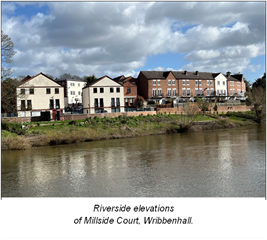
- Unsympathetic shop fronts, including the following:
- No. 16 Load Street (formerly HSBC) has benefited from a generally well-executed programme of restoration to the upper floors and wider building fabric, which has significantly enhanced its contribution to the character and appearance of the Conservation Area. However, the ground floor shopfront remains unsympathetic in its current form. The proportions and detailing of the windows, the treatment of the brickwork, and the entablature course do not reflect the building’s historic architectural language or the prevailing character of Load Street.
- There remains scope for enhancement at ground floor level, potentially through the reintroduction of a more classically composed frontage. This could include reinstating door openings (which may be expressed architecturally rather than functionally) with appropriately detailed doorcases and pediments, the introduction of glazing bars, the use of rubbed gauged brick headers to window openings, and selective brick replacement or repair to achieve a closer match to the historic fabric. Such measures would complete the building’s restoration and further strengthen its presence within the streetscape.
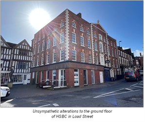
- No. 40 Load Street (Carpet Shop) retains a flat roof introduced during the mid-twentieth century, which contrasts with the traditional pitched and tiled roofscape characteristic of the street. There would be scope, should the opportunity arise, to reinstate a pitched tiled roof more in keeping with the prevailing architectural form.
- At No. 49 Load Street (formerly Jackson’s Butcher), the previously prominent blue glazed tiles to the shopfront have now been removed, improving the building’s appearance within the streetscape. Continued enhancement of the ground floor frontage, through a more traditionally proportioned and detailed shopfront and appropriately designed signage or blind, would further strengthen its contribution to the character of the Area.
- Nos. 50 and 51 Load Street (formerly Co-op) are currently unoccupied. The existing shopfront treatment remains of a late twentieth-century style that does not fully reflect the traditional proportions and detailing of neighbouring premises. The vacancy presents an opportunity for future reinstatement of a more historically informed shopfront design. In addition, alterations to the first-floor Venetian window at No. 50 have diminished its architectural integrity; reinstating traditionally detailed sash windows and glazing bars would enhance the building’s upper façade.
- Nos. 57 and 58 Load Street retain recessed shopfronts of a modern style that sit somewhat at odds with the traditionally front-mounted rhythm of the street. There would be potential, in the longer term, to reinstate front-mounted shopfronts more closely aligned with historic precedents.
- No. 65 Load Street features fascia lettering that is bold in colour, scale and style relative to the surrounding historic context. Replacement with more restrained, traditionally proportioned hand-painted signage would better complement the building and wider streetscape.
- No. 1 Severnside South has a ground floor shopfront and associated alterations that do not fully reflect the building’s historic character, including painted brickwork, simplified detailing to the first-floor canted windows and a modern plastic door canopy. Opportunities remain to enhance the frontage through a more traditionally detailed shopfront, reinstatement of appropriate cornices to the canted windows, and removal of the plastic canopy.
In addition to the enhancement of the specific sites and features identified above, the wider character and appearance of the Conservation Area would benefit from a coordinated programme of public realm improvements. This could include the gradual replacement of tarmacadam surfaces and concrete kerbs with more sympathetic, high-quality materials appropriate to the historic setting; the introduction of street lighting columns, signage poles, roadside railings and bus shelters of a design better aligned with local character; and, where feasible, the rationalisation or undergrounding of overhead cabling.
4.24 Neutral Sites
A neutral area is defined as a part of the Conservation Area whose character does not conform to that of its immediate surroundings. Such areas may detract from the overall quality and cohesion of the Conservation Area but can often be improved through sensitive management and redevelopment.
Remedial approaches typically involve ensuring that, where an existing use is to continue, any proposals for alteration or redevelopment should be:
- Confined to parts of the site not visible to the public realm, thereby minimising visual intrusion; or
- Designed to incorporate discreet and subtle references to the predominant materials, scale, and design features of the surrounding historic environment.
Ideally, where feasible and appropriate, uncharacteristic or intrusive features should be removed and replaced with new structures or landscaping of a scale, form, and appearance consistent with the character of the Conservation Area. However, careful consideration should always be given to ensure that an uncharacteristic feature is not, in fact, an important remnant of the Area’s historical development which, despite its incongruity, may merit retention.
Identified Neutral Site:
- Texaco Petrol Filling Station and Shop, Kidderminster Road.
 Texaco petrol filling station and shop, Kidderminster Road
 - Lock-up garages to the rear of Police Station, Kidderminster Road.
- Extensions to the north east corner of St. George’s Hall (Load Street) and Lavatories to the rear of No. 69 Load Street (unsympathetic late 20th century buildings).
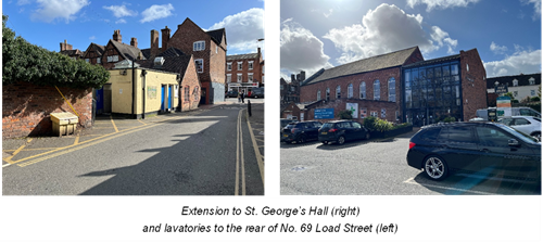
- Telephone exchange, Dowles Road, and in particular the northeast facing mono pitch roof, dark brickwork, uncharacterful fenestration and satellite dish.
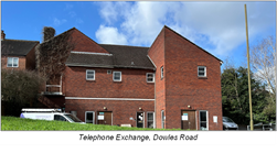
- Unsympathetic twentieth century dwellings in Maypole Close and Telford Drive (adjoining the Conservation Area but in sensitive locations); and Park Close, Kidderminster Road (Nos. 27 to 33) and No. 63a High Street (within the Conservation Area and in sensitive locations).
- Bridge House and adjoining commercial buildings in Riverside North. (Adjoining the Conservation Area but in a prominent position).
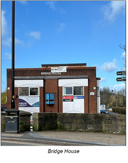
4.25 Condition of Buildings and Structures
Most buildings and structures within the Conservation Area are in good or fair condition and continue to contribute positively to its character and appearance. A small number of buildings have historically required intervention due to vacancy, vulnerability to flooding or general deterioration. Those that have been included in previous appraisals include:
- Number 3 Beale’s Corner, a vacant timber-framed dwelling in an area formerly prone to seasonal flooding, has long been identified as vulnerable. The completion of the town’s flood defence works has significantly reduced flood risk within this part of the Conservation Area, improving the prospects for the building’s repair, sustainable reuse and long-term conservation.
- The former Old Workhouse to the rear of No. 63 High Street is a substantial three-storey building that had remained vacant for some time. Planning permission has now been granted for its rebuild and conversion, securing a viable new use and enabling the retention of its historic form and character. The implementation of this approved scheme represents a positive step toward safeguarding the building’s significance and reducing the number of heritage assets at risk within the Area.
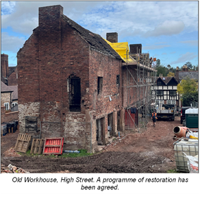
- 63 High Street itself is in a poor state and is continuously deteriorating. Its poor condition is at odds with the rest of Load Street and is a detriment to the conservation area.
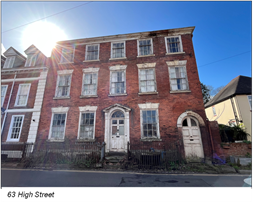
- Outbuildings (possibly former washhouse and bakery) rear 14 & 15 High Street.
- 2 and 3 Severnside South continue to require regular maintenance attention. Rainwater goods are prone to blockage, largely due to persistent pigeon activity, necessitating frequent clearance to prevent water ingress and associated fabric decay. Elements of external timberwork also require ongoing repair and redecoration to ensure their long-term preservation and to prevent incremental deterioration.
- The central bridge, including its principal balustrades and those extending towards Beale’s Corner, has now undergone a comprehensive and sympathetic programme of restoration. Previous concerns included intermittent vehicle damage, weathering of stonework, and the use of inappropriate repair materials such as non-stone copings and concrete footings to certain piers. The land arches on the north side adjoining Beale’s Corner had also required attention. The completed restoration works have addressed these issues using appropriate materials and conservation techniques, resulting in a significant enhancement to the structure’s condition and appearance. The quality and extent of the works were sufficient to secure the removal of the bridge and its balustrades from Historic England’s Heritage at Risk Register, representing a notable achievement in the stewardship of this key landmark within the Conservation Area.
5.0 Conclusion
Bewdley Conservation Area possesses considerable architectural and historic significance. The town’s origins lie in its strategic position as a principal crossing point of the River Severn during the medieval period which, combined with its role as an inland port, established Bewdley as a thriving centre of trade and commerce. This prosperity continued into the late eighteenth and early nineteenth centuries and is reflected in the town’s rich and varied built fabric.
Many of Bewdley’s buildings, particularly those dating from the late medieval and Georgian periods, display a high degree of craftsmanship and architectural quality which together define the town’s distinctive and recognisable character. These buildings establish an important benchmark for the scale, materials and detailing of any new development or alteration within the Conservation Area.
The arrival of the railway in the mid-nineteenth century introduced additional layers of character, most notably through the Victorian architectural influences visible in parts of Wribbenhall and around the station. Together, these successive phases of development have created a townscape of considerable historic depth and visual richness.
The preservation and careful management of this historic environment is therefore essential. The Conservation Area designation seeks to ensure that change within Bewdley is appropriately managed so that its architectural integrity, historic character and important relationship with the River Severn and surrounding landscape are maintained. The appraisal provides a clear understanding of the elements which contribute positively to the significance of the area and will serve as a guiding framework for future development, ensuring that Bewdley’s distinctive character is preserved and enhanced for future generations.
Map of the conservation area
Conservation area map: There are no planned boundary changes. This document may not be suitable for users of assistive technology. Please contact planning.policy@wyreforestdc.gov.uk for more information.